Saint-Louis-Arzviller inclined plane
Boat liftsBuildings and structures in Moselle (department)Canal inclined planesTourist attractions in Moselle (department)Transport in Grand Est ... and 1 more
Transport infrastructure completed in 1969
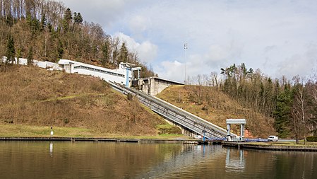
The Saint-Louis-Arzviller inclined plane is an inclined plane on the Marne-Rhine Canal (French: Canal de la Marne au Rhin) that enables the canal to cross the Vosges Mountains. It is located in the commune of Saint-Louis, between the towns of Saint-Louis and Arzviller in the département of the Moselle.
Excerpt from the Wikipedia article Saint-Louis-Arzviller inclined plane (License: CC BY-SA 3.0, Authors, Images).Saint-Louis-Arzviller inclined plane
Rue des Sources, Sarrebourg-Château-Salins
Geographical coordinates (GPS) Address Phone number Nearby Places Show on map
Geographical coordinates (GPS)
| Latitude | Longitude |
|---|---|
| N 48.715833333333 ° | E 7.2183333333333 ° |
Address
Sophie-Marie
Rue des Sources
57820 Sarrebourg-Château-Salins
Grand Est, France
Open on Google Maps


