place

Sierra Vista, Arizona

Cities in ArizonaCities in Cochise County, ArizonaMicropolitan areas of ArizonaSierra Vista, ArizonaUse mdy dates from July 2023
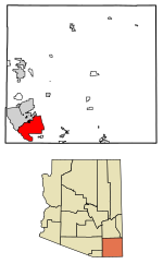
Cochise County Arizona Incorporated and Unincorporated areas Sierra Vista Highlighted 0466820

Sierra Vista is a city in Cochise County, Arizona, United States. According to the 2020 Census, the population of the city is 45,308, and is the 27th most populous city in Arizona. The city is part of the Sierra Vista-Douglas Metropolitan Area, with a 2010 population of 131,346. Fort Huachuca, a U.S. Army post, has been incorporated and is located in the northwest part of the city. Sierra Vista is bordered by the cities of Huachuca City and Whetstone to the north and Sierra Vista Southeast to the South. Sierra Vista, Spanish for 'mountain view', is 75 miles (121 km) southeast of Tucson and serves as the main commercial, cultural, and recreational hub of Cochise County. Sierra Vista is located on the southwestern side of Cochise County and is 15 miles (24 km) southwest of Tombstone, 20 miles (32 km) northwest of Bisbee, and 15 miles (24 km) from the border of Mexico. The closest port of entry to Mexico is Naco in the Mexican state of Sonora which is 24 miles (39 km) from Sierra Vista to the southeast. Sierra Vista is home to University of Arizona, College of Applied Science and Technology, a Defense Intelligence Agency (DIA) designated Intelligence Community - Center of Academic Excellence (IC-CAE) university, Cochise College, and Wick Communications, a media company operating 27 newspapers and 18 specialty publications in 11 states.

Excerpt from the Wikipedia article Sierra Vista, Arizona (License: CC BY-SA 3.0, Authors, Images).

Sierra Vista, Arizona
Tiffany Place, Sierra Vista

Geographical coordinates (GPS) Address Nearby Places
placeShow on map

Wikipedia: Sierra Vista, ArizonaContinue reading on Wikipedia

Geographical coordinates (GPS)

Latitude Longitude
N 31.545555555556 ° E -110.27638888889 °
placeShow on map

Address

Tiffany Place 2099
85635 Sierra Vista
Arizona, United States
mapOpen on Google Maps

Cochise County Arizona Incorporated and Unincorporated areas Sierra Vista Highlighted 0466820
Share experience

Nearby Places

Fry Pioneer Cemetery

Fry Pioneer Cemetery is the original cemetery in Fry, Arizona, which was the name of Sierra Vista prior to its renaming and incorporation in 1956. It is a half-acre site, and includes more than 200 known graves, most of which are unmarked. It has sparse vegetation and is surrounded by a chain-link fence.The cemetery is a mile east of Fort Huachuca, an active military installation, completely enclosed by urban development. It is located between Sixth and Seventh Streets in Fry, Arizona, which is an unincorporated community wholly within the bounds of the city of Sierra Vista. It is accessible from both Fry Boulevard and the State Highway 90 bypass. There is sparse vegetation, and no planned walkways or landscaping, having developed organically over the years.The entire cemetery is surrounded by a chain link fence, installed in the 1960s. There is an entrance on the west side. Inside the cemetery is a three-foot brick wall which encloses the family plot of Oliver Fry and his family. The family plot has thirteen graves, all of which have headstones, although one is broken and without an inscription. Outside the family plot, the vast majority of the graves are unmarked. Outside the historic cemetery there are other unmarked graves on the south and east side, some of which have been identified as the resting place of Yaqui Indians. Also outside the historic cemetery, on the east side of Seventh Street, under a commercial parking lot, lie more burial sites.The cemetery was established in 1919 when Oliver Fry buried his wife, Elizabeth. The cemetery was in general use between 1919 and 1958, but now is only open to burials of descendants of the Fry family. The latest interment was a great-granddaughter of Oliver and Elizabeth in 2005.

The Mall at Sierra Vista

The Mall at Sierra Vista is an indoor shopping center in Sierra Vista, Arizona, United States owned and managed by Kohan Retail Investment Group. It was constructed during the late 1990s. Sierra Vista was one of the fastest-growing communities in Arizona and the major population center for southeastern Arizona. The developers had hoped to market to the growing community, which had no other malls. It was the first major mall to be built in southeastern Arizona, with of retail space.This regional mall serves a large portion of southeastern Arizona and northern parts of the Mexican state of Sonora. A recent survey indicated that as much as 30% of the mall's shoppers come from Sonora, traveling as far away as Nacozari and Cumpas, 120 miles (190 km) south of the border, just to shop there.In addition to shopping, the Mall at Sierra Vista hosts the annual Festival of Trees, the Festival of Giving, and an annual Car Show for the Boys and Girls Club. The Mall merits a mention in Ethel Jackson Price's 2003 book, Sierra Vista: a Young City with a Past.In 2015, Sears Holdings spun off 235 of its properties, including the Sears at The Mall as Sierra Vista, into Seritage Growth Properties. On October 15, 2018, it was announced that Sears would be closing as part of a plan to close 142 stores nationwide. In January 2019, Seritage listed the Sears property for sale due to limited redevelopment opportunities.In May 2019, the mall was listed for sale; For 2 years, no buyer has been found. Then in July 2021, Kohan Retail Investment Group purchased the mall alongside 6 other malls from Brookfield Asset Management.

Fort Huachuca
Fort Huachuca

Fort Huachuca is a United States Army installation, established on 3 March 1877 as Camp Huachuca. The garrison is now under the command of the United States Army Installation Management Command. It is in Cochise County in southeast Arizona, approximately 15 miles (24 km) north of the border with Mexico and at the northern end of the Huachuca Mountains, adjacent to the town of Sierra Vista. From 1913 to 1933, the fort was the base for the "Buffalo Soldiers" of the 10th Cavalry Regiment. During the build-up of World War II, the fort had quarters for more than 25,000 male soldiers and hundreds of WACs. In the 2010 census, Fort Huachuca had a population of about 6,500 active duty soldiers, 7,400 military family members, and 5,000 civilian employees. Fort Huachuca has over 18,000 people on post during weekday work hours. The major tenant units are the United States Army Network Enterprise Technology Command (NETCOM) and the United States Army Intelligence Center. Libby Army Airfield is on post and shares its runway with Sierra Vista Municipal Airport. It was an alternate but never used landing location for the Space Shuttle. Fort Huachuca is the headquarters of Army Military Auxiliary Radio System. Other units include the Joint Interoperability Test Command, the Information Systems Engineering Command, the Electronic Proving Ground (USAEPG), and the Intelligence and Electronic Warfare Directorate.The fort has a radar-equipped aerostat (Tethered Aerostat Radar System), one of a series maintained for the Drug Enforcement Administration (DEA) by Harris Corporation. The aerostat is northeast of Garden Canyon and supports the DEA drug interdiction mission by detecting low-flying aircraft attempting to enter the United States from Mexico. Fort Huachuca contains the Western Division of the Advanced Airlift Tactics Training Center which is based at the 139th Airlift Wing, Rosecrans Air National Guard Base in Saint Joseph, Missouri.