place

Folsom Dam

1956 establishments in CaliforniaBuildings and structures in Folsom, CaliforniaCentral Valley ProjectDams completed in 1956Dams in California
Dams on the American RiverEnergy infrastructure completed in 1956Hydroelectric power plants in CaliforniaUnited States Bureau of Reclamation dams
Folsom Dam Release
Folsom Dam Release

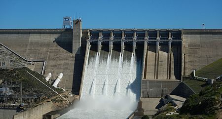
Folsom Dam is a concrete gravity dam on the American River of Northern California in the United States, about 25 mi (40 km) northeast of Sacramento. The dam is 340 ft (100 m) high and 1,400 ft (430 m) long, flanked by earthen wing dams. It was completed in 1955, and officially opened the following year. Located at the junction of the north and south forks of the American River, the dam was built by the United States Army Corps of Engineers, and was transferred to the United States Bureau of Reclamation upon its completion. The dam and its reservoir, Folsom Lake, are part of the Central Valley Project, a multipurpose project that provides flood control, hydroelectricity, irrigation, and municipal water supply. To increase Sacramento's flood protection to 200-year flood protection (meaning that the area is protected from a flood that has a 0.5% chance of occurring in any given year), the Corps of Engineers recently constructed an auxiliary spillway, which was completed in October 2017; it enables Folsom Dam operators to increase outflows to prevent the lake level from reaching or exceeding the height of the main dam gates.Another Central Valley Project dam, Nimbus Dam, is located further down river.

Excerpt from the Wikipedia article Folsom Dam (License: CC BY-SA 3.0, Authors, Images).

Folsom Dam
Folsom Dam Road, Folsom

Geographical coordinates (GPS) Address Nearby Places
placeShow on map

Wikipedia: Folsom DamContinue reading on Wikipedia

Geographical coordinates (GPS)

Latitude Longitude
N 38.7077 ° E -121.1565 °
placeShow on map

Address

Folsom Dam Road

Folsom Dam Road
95671 Folsom
California, United States
mapOpen on Google Maps

Folsom Dam Release
Folsom Dam Release
Share experience

Nearby Places

North Fork American River

The North Fork American River is the longest branch of the American River in Northern California. It is 88 miles (142 km) long from its source at the crest of the Sierra Nevada, near Lake Tahoe, to its mouth at Folsom Lake northeast of Sacramento. Prior to the construction of Folsom Dam the river was about 9 miles (14 km) longer making for a total length of 97 miles (156 km). It rises at Mountain Meadow Lake near the 9,008 ft (2,746 m) peak of Granite Chief in the Tahoe National Forest. Flowing initially northwest, the river soon swings west into a gorge, paralleling the Forest Hill Divide on the south. Big Granite Creek then joins the North Fork of the American River coming in from the right. The canyon shallows as the river turns southwest, carving through the Sierra foothills, then turning abruptly south near Colfax. About 4 miles (6.4 km) downstream, it receives Shirttail Creek from the left then is impounded in Lake Clementine (or North Fork Lake) which is formed by the North Fork Dam, built in 1939 to contain hydraulic mining debris.Below the dam, the river bends south, passing under the Foresthill Bridge, the highest bridge in California, then receives the Middle Fork American River, its largest tributary, from the left. The valley widens as the river flows south past Auburn, soon emptying into the north arm of Folsom Lake, a reservoir formed in 1955 by the Folsom Dam. Its waters merge in the lake with those of the South Fork American River and form the American River, a tributary of the Sacramento River.

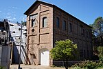
Folsom Powerhouse State Historic Park

Folsom Powerhouse State Historic Park is a historical site preserving an 1895 alternating current (AC) hydroelectric power station—one of the first in the United States. Before the Folsom powerhouse was built nearly all electric power houses were using direct current (DC) generators powered by steam engines located within a very few miles of where the power was needed. The use of rushing water to generate hydroelectric power and then transmitting it long distances to where it could be used was not initially economically feasible as long as the electricity generated was low-voltage direct current. Once it was invented, AC power made it feasible to convert the electrical power to high voltage by using the newly invented transformers and to then economically transmit the power long distances to where it was needed. Lower voltage electrical power, which is much easier and safer to use, could be easily gotten by using transformers to convert the high voltage power to lower voltages near where it was being used. DC power cannot use a transformer to change its voltage. The Folsom Powerhouse, using part of the American River's rushing water to power its turbines connected to newly invented AC generators, generated three phase 60 cycle AC electricity (the same that's used today in the United States) that was boosted by newly invented transformers from 800 volts as generated to 11,000 volts and transmitted to Sacramento over a 22 mi (35 km)-long distribution line, one of the longest electrical distribution lines in the United States at the time.