Kafr Jammal
Municipalities of the State of PalestineTulkarm GovernorateVillages in the West Bank

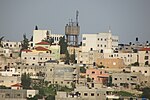
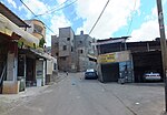
Kafr Jammal (Arabic: كفر جمّال), is a Palestinian town in the Tulkarm Governorate in the western edge of the West Bank. It is located about halfway between Qalqilyah and Tulkarm, and had a population of 2,855 in 2017. The village is mainly agricultural, and mostly raises olive and citrus crops. Kafr Jammal is at an altitude of 257 meters, and is bordered by Falamya (Falameh, Falāma) in the west, Kafr Zibad in the east, Jayyous in the south, and Kafr Sur to the north.
Excerpt from the Wikipedia article Kafr Jammal (License: CC BY-SA 3.0, Authors, Images).Kafr Jammal
Geographical coordinates (GPS) Address Nearby Places Show on map
Geographical coordinates (GPS)
| Latitude | Longitude |
|---|---|
| N 32.225277777778 ° | E 35.044166666667 ° |
Address
Palestinian Territories
Open on Google Maps


