place

Mercer Caverns

Caves of CaliforniaLandforms of Calaveras County, CaliforniaLimestone cavesShow caves in the United StatesTourist attractions in Calaveras County, California
United States geology stubs
Mercer Caverns tour
Mercer Caverns tour

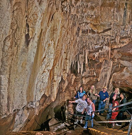
Mercer Caverns is a show cave located one mile north of Murphys in Calaveras County California. It is named after the gold prospector Walter J. Mercer who discovered the caves around 1885 and filed a claim. The caverns have a large number of speleothems, stalactites, and stalagmites. It is formed in a marble unit known as the Calaveras Formation. It also contains a large display of aragonite frostwork. The standard tour of the cave descends 160 feet, 208 steps down and 232 up in a traverse between the natural and an artificial entrance. The cave was mapped in 1986 to a length of 3389 feet and a total depth of 192 feet. The map can be viewed on the cave's web site.

Excerpt from the Wikipedia article Mercer Caverns (License: CC BY-SA 3.0, Authors, Images).

Mercer Caverns
Mercer Cave Road,

Geographical coordinates (GPS) Address Nearby Places
placeShow on map

Wikipedia: Mercer CavernsContinue reading on Wikipedia

Geographical coordinates (GPS)

Latitude Longitude
N 38.151388888889 ° E -120.47833333333 °
placeShow on map

Address

Mercer Cave Road
96249
California, United States
mapOpen on Google Maps

Mercer Caverns tour
Mercer Caverns tour
Share experience

Nearby Places

Old mining camp of Brownsville

The site of the Old Mining Camp of Brownsville is a California Historical Landmark on Pennsylvania Gulch Road east of the town of Murphys, California in Calaveras County. The Mining Camp of Brownsville was a California Gold Rush camp in Pennsylvania Gulch in from 1850 to 1870. The camp is named after Alfred Brown, who was the former owner of the Table Mountain Ranch. There were many rich mines in the area and Brownsville Mining Camp supported this activity. So rich was the area, the Brownsville Mining District limited the size of mines in the District. Each miner could claim and own only one wet and one dry site, no larger than 150 square feet (14 m2) each. Brownsville Mining District was in the area of Pennsylvania Gulches and Missouri Gulches 2 miles from Murphys. There are no remains of the camp, but nearby is the Brownsville Mining District Cemetery. A plaque monument was dedicated on July 19, 1953, by California State Park Commission with the monument base built by Christa Parlor No. 137 and Ruby Parlor No. 49 of the Native Daughters of the Golden West.Table Mountain Ranch was 1,300-acre ranch that started a mile east of the city of Murphys and ran to the Stanislaus River. The ranch's was bordered on the west by Coyote Creek. George Brown founded the ranch in the 1850, and supported the gold rush miners. George Brown sold the ranch in 1860 to William. Auditt and George March. In 1882 the ranch was sold to Leo Dolan and again sold in 1889 it was sold to William and Ethel Adams, mining engineer from Boston. After their divorce, William sold the ranch to Ethel's father. Ethel ran the ranch and had a herd of beef cattle, Jersey dairy cows, swine and horses. The ranch also became an orchard with English walnuts, almonds, French prunes, peachas, grapes and apples. Ethel died in 1927 and left the ranch to its foreman, Fred Kenney. Kenney operated the Dairy till 1940. Kenney raised cattle until 1963, in 1963 when Kenney sold the ranch to David Kentfield. Kentfield subdivided some of Ranch. Some Hollywood movies were shot on Table Mountain Ranch including: The County Chairman in 1935 with Will Rogers, The Farmer Takes a Wife in 1935 with Janet Gaynor and Henry Fonda, The Red House in 1947 with Edward G. Robinson, and Seven Brides for Seven Brothers in 1954. Only raimaning building of the ranch is the Dairy barn on 70-acres, that is now the Indian Rock Vineyards at 38.1300°N 120.4381°W / 38.1300; -120.4381.