Ōmawete / Coopers Knob
Canterbury, New Zealand geography stubsGeography of ChristchurchMountains of Canterbury, New ZealandUse New Zealand English from February 2024
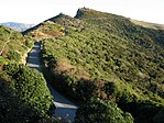
Ōmawete / Coopers Knob is a hill in the Port Hills approximately 13.5 kilometres (8.4 mi) south of Christchurch, New Zealand. It is the highest point on the Port Hills, at 573 metres (1,880 ft).Coopers Knob sits between Tai Tapu to the west and Governors Bay to the east. Below the summit is the 39 acres (16 ha) Cooper's Knob Reserve, created in 1948 by the Christchurch City Council
Excerpt from the Wikipedia article Ōmawete / Coopers Knob (License: CC BY-SA 3.0, Authors).Ōmawete / Coopers Knob
Crater Rim Walkway,
Geographical coordinates (GPS) Address External links Nearby Places Show on map
 Continue reading on Wikipedia
 Geographical coordinates (GPS)
| Latitude | Longitude |
|---|---|
| N -43.661111111111 ° | E 172.625 ° |
Address
Crater Rim Walkway
Crater Rim Walkway
, Tai Tapu
Canterbury, New Zealand
Open on Google Maps