place

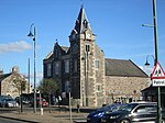
Biggar Corn Exchange

Biggar, South LanarkshireCategory B listed buildings in South LanarkshireCommercial buildings completed in 1861Corn exchanges in ScotlandUse British English from October 2023
Biggar geograph.org.uk 3677471

Biggar Corn Exchange is a commercial building in the High Street, Biggar, South Lanarkshire, Scotland. The structure, which is now used as a theatre, is a Category B listed building.

Excerpt from the Wikipedia article Biggar Corn Exchange (License: CC BY-SA 3.0, Authors, Images).

Biggar Corn Exchange
John Street,

Geographical coordinates (GPS) Address External links Nearby Places
placeShow on map

Wikipedia: Biggar Corn ExchangeContinue reading on Wikipedia

Geographical coordinates (GPS)

Latitude Longitude
N 55.6244 ° E -3.5217 °
placeShow on map

Address

Corn Exchange

John Street
ML12 6DH
Scotland, United Kingdom
mapOpen on Google Maps

linkWikiData (Q17845921)
linkOpenStreetMap (10936305098)

Biggar geograph.org.uk 3677471
Share experience

Nearby Places

Coulter, South Lanarkshire

Coulter or Culter (both spellings in use, pronounced "Cooter" with no "l") is a small village and civil parish in South Lanarkshire, Scotland. It lies approximately 3 miles (4.8 km) south of Biggar. Some old maps and local modern houses also have the spelling Cootyre - "a safe place for cows." Nearby are two notable Scottish hills, Tinto and Culter Fell. The River Clyde is also nearby. Coulter Village at Culter House is on the watershed between the Clyde and the Tweed. The village has a mill which has been converted to a restaurant. The second recorded Mill some time about 1880. The site of the first since the burn, Culter Water, was diverted to its present course is unknown. The village is the likely location of the fictional Midculter from Dorothy Dunnett's 6-book series The Lymond Chronicles. Within that series, Midculter is the home of the Crawford Barons of Culter and of the protagonist, Francis Crawford of Lymond. A possible location for their castle, Midculter Castle, is Coulter Motte. Coulter Motte lies some distance from the village on the side of the Clyde at Wolf Clyde, it is a small lump of ground adjacent to the river at a point where it is diverted by ditch toward the Tweed, to alleviate the flood water. Some enterprising person in the past had the idea of fully diverting the waters of the Clyde at this point toward the Tweed. It does not accommodate the descriptions in the Books of the Lymond Series of avenue of Trees, and surrounding hillsides- mention of the closeness to the major River do not appear. The Monks of Kelso and the Templars feature in the early history of Culter, many place, and farm names would enforce the latters presence. A more likely site of the Castle of Culter referred to fictionally in the books of Dorothy Dunnett would be Culter House (circa 1680) later of course than the date of the series but nonetheless the oldest inhabited house in the upper ward of Lanarkshire, with its attendant mile long avenue of trees, extant on Roys map of 1746/7, and mentioned in Buchan's John Burnet of Barns.One famous son would be James Gillray (1757-1815), a memorial to whom rests in the Kirkyard. Caricaturist - political satirist of the Georgian and Napoleonic period. Coulter Mains was built in the Elizabethan Gothic style in 1838, designed by William Spence (1806-1883). The local antiquarian Adam Sim (1805–1868) lived there with his large collection of objects, many of which are now in the National Museum of Antiquities, Edinburgh.

Skirling
Skirling

Skirling is a parish, community council area and village in Peeblesshire in the Scottish Borders situated 2+1⁄2 miles east of Biggar in Lanarkshire. Biggar Water, a tributary the River Tweed forms the southern boundary of the parish with the parish of Broughton, Glenholm and Kilbucho. It is also bounded by that parish on the east, namely the Broughton part of it. On the north it is bounded by the parish Kirkurd in Peeblesshire. Spittal Burn forms most of its western boundary with Lanarkshire. The parish lies in the Southern Uplands. Its village is 690 ft above sea level. Its length, north to south, is 3 miles and it is 2 miles at most wide. The highest point in the parish is Broomy Law, 1399 ft, on the north-west boundary. At its northernmost point the parish is met by 5 other parishes (boundary stone at site). The earliest known record of Skirling by name dates from the reign of King Robert Bruce, who granted the barony of Scrawline to John Monfode. The barony of Skirling was possessed by the Cockburn family c.1370 - 1621 and during the 18th and 19th centuries by the Carmichael family. Thomas Gibson-Carmichael was raised to peerage of the United Kingdom in 1912 as Baron Carmichael of Skirling, but this title became extinct on his death in 1926. He commissioned the building of Skirling House in 1905. The earliest record of a church is in 1275, sited near the present war memorial. Former ministers include John Greig. In 1843, William Hanna left the established Church of Scotland in 1843, joining the Free Church of Scotland, taking most of his congregation with him. The present building was rebuilt in 1720 and was much altered in 1891. It has a pleasant bell tower with a sundial, the bell dating from 1748. Ironwork on the graveyard gates is by Thomas Hadden and the Carmichael family plot is flanked by two charming angel sculptures. The church is now a member of the linked "Parishes of Upper Tweeddale", which is made up of four neighbouring Parishes.The Skirling Community Council area is the same as the civil parish. The council has 6 members.The village of Skirling has a central position in the parish. It originally consisted of five small farms on the valley floor of Skirling Burn, forming a roughly linear shaped settlement. The village is a conservation area, which includes the parish church, the old Free church, Skirling House, along with many 1 - 2 story buildings made from traditional materials. Just south-west of the village is the site of Skirling Castle, described as "ane notable beilding" and demolished and burnt by Regent Moray on 12 June 1568.The village war memorial was designed by Sir Robert Lorimer and added in 1920.The civil parish has a population of 194 (in 2011) and its area is 3,423 acres.At 11.18am on 31 December 2020 Skirling was the epicentre of a 1.9 Magnitude earthquake which was also felt in Biggar, Symington, West Linton and Peebles. Locals reported that they heard a "loud bang" or "loud rumbling noise" and that the "room shuddered".