place

Gifford Town Hall

Category B listed buildings in East LothianCity chambers and town halls in ScotlandGovernment buildings completed in 1884Use British English from August 2022
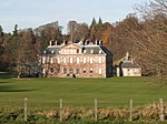
Town Hall in Gifford (geograph 6407554)

Gifford Town Hall is a municipal building in The Square, Gifford, East Lothian, Scotland. The structure, which is used as a community events venue, is a Category B listed building.

Excerpt from the Wikipedia article Gifford Town Hall (License: CC BY-SA 3.0, Authors, Images).

Gifford Town Hall
The Square,

Geographical coordinates (GPS) Address Nearby Places
placeShow on map

Wikipedia: Gifford Town HallContinue reading on Wikipedia

Geographical coordinates (GPS)

Latitude Longitude
N 55.9031 ° E -2.7476 °
placeShow on map

Address

The Square

The Square

Scotland, United Kingdom
mapOpen on Google Maps

Town Hall in Gifford (geograph 6407554)
Share experience

Nearby Places

East Lothian
East Lothian

East Lothian (; Scots: East Lowden; Scottish Gaelic: Lodainn an Ear) is one of the 32 council areas of Scotland, as well as a historic county, registration county and lieutenancy area. The county was called Haddingtonshire until 1921. In 1975, the historic county was incorporated for local government purposes into Lothian Region as East Lothian District, with some slight alterations of its boundaries. The Local Government etc. (Scotland) Act 1994 later created East Lothian as one of 32 modern council areas. East Lothian lies south of the Firth of Forth in the eastern central Lowlands of Scotland. It borders Edinburgh to the west, Midlothian to the south-west and the Scottish Borders to the south. Its administrative centre and former county town is Haddington while the largest town is Musselburgh. Haddingtonshire has ancient origins and is named in a charter of 1139 as Hadintunschira and in another of 1141 as Hadintunshire. Three of the county's towns were designated as royal burghs: Haddington, Dunbar, and North Berwick. As with the rest of Lothian, it formed part of the Anglo-Saxon kingdom of Bernicia and later the Kingdom of Northumbria. Popular legend suggests that it was at a battle between the Picts and Angles in the East Lothian village of Athelstaneford in 823 that the flag of Scotland was conceived. From the 10th century, Lothian transferred from the Kingdom of England to the authority of the monarchs of Scotland. It was a cross-point in battles between England and Scotland and later the site of a significant Jacobite victory against Government forces in the Battle of Prestonpans. In the 19th century, the county is mentioned in the Gazetteer for Scotland as chiefly agricultural, with farming, fishing and coal-mining forming significant parts of the local economy.

Bara, East Lothian
Bara, East Lothian

Bara, anciently spelt Baro, is an agricultural parish in East Lothian, Scotland, which adjoins the parish of Garvald to the east, and Lauder across the Lammermuir Hills. It is south-west of Haddington. About 1340, Robert de Lawder, Justiciary, was a witness, with James Lord Douglas, Robert de Keith, Henry St.Clair, Alexander de Seaton, all knights, plus the "Lord" William, Rector of the parish of Morham, East Lothian, to a charter of Euphemia, the widow of Sir John Giffard, Lord of Yester, relating to the tenement of land of 'Barow'. This was once a separate community and parish, with its own church and graveyard, which stood in a corner of Linplum farm – to this day called kirk field. In 1743, part of the roof of the ancient church collapsed. The community was in some decline and the Presbytery decided not to repair the church but to conjoin the parish with adjoining Garvald, notwithstanding the fact that Morham church was slightly closer. The Glebe was on the north side of the road leading to Garvald and the manse stood where, in 1890, the Bara blacksmith's premises stood. The superiority of the parish was long in the hands of the Hays of Yester family and their cadets, and following the demise of Bara Kirk, Robert Hay, of Bara & Linplum, enclosed the churchyard with a wall and planted it with trees and shrubs. Some of the church ruins are extant and just a few of the original headstones in the totally overgrown graveyard. Some of the older headstones were readable in the 19th century and half a dozen appear in John Martine's book. Others were transcribed in the 1950s. The community has today all but disappeared with the demise of agricultural labour, although numerous farms still exist: Carfrae, Duncanlaw, Bara, Linplum, Snawdon, Little Newton, Quarryford, Newlands, Castlemains, Danskin, Brokside, and East & West Hopes.