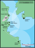
The Hobart coastal defences are a network of now defunct coastal batteries, some of which are inter-linked with tunnels, that were designed and built by British colonial authorities in the nineteenth century to protect the city of Hobart, Tasmania, from attack by enemy warships. During the nineteenth century, the port of Hobart Town was a vital re-supply stop for international shipping and trade, and therefore a major freight hub for the British Empire. As such, it was considered vital that the colony be protected. In all, between 1804 and 1942 there were 12 permanent defensive positions constructed in the Hobart region.Prior to Australian Federation, the island of Tasmania was a colony of the British Empire, and as such was often at war with Britain's enemies and European rivals, such as France and later Russia. The British had already established the colony of Sydney at Port Jackson in New South Wales in 1788, but soon began to consider the island of Tasmania as the potential site of a useful second colony. It was an island, cut off from the mainland of Australia and isolated geographically, making it ideal for a penal colony, and was rich in timber, a resource useful to the Royal Navy. In 1803, the British authorities decided to colonise Tasmania, and to establish a permanent settlement on the island that was at the time known as Van Diemen's Land, primarily to prevent the French from doing so. During this period tensions between Great Britain and France remained high. The two nations had been fighting the French Revolutionary Wars with each other through much of the 1790s, and would soon be engaging each other again in the Napoleonic Wars.The first permanent British settlement in Van Diemen's Land had begun on 8 September 1803, at Risdon Cove on the Derwent River's eastern shore. However, the arrival of Lieutenant-Governor David Collins on 16 February 1804, saw him make the decision to relocate the settlement to Sullivan's Cove on the western shore of the Derwent River. Within days of the settlement's establishment, Collins had decided the new colony would need protection should the French send warships up the river to threaten the fledgling colony. A crude earthwork redoubt was dug into an elevated position near the centre of Sullivan's Cove, in the area that is now Franklin Square, and two ships cannons were placed inside. For the next seven years, this muddy emplacement would serve as the only defensive position of what was growing to become Hobart Town.When Governor Lachlan Macquarie toured the Hobart Town settlement in 1811, he was alarmed at the poor state of the defences and the general disorganisation of the colony. Along with planning for a new grid pattern of streets to be laid out, and new administrative and other buildings to be built, he commissioned the building of Anglesea Barracks, which opened in 1814, and is now the oldest continually occupied barracks in Australia. Macquarie also suggested the construction of more permanent fortifications. Following his advice, a new location comprising an area of 8 acres (32,000 m2) was selected at the eastern end of Battery Point on the southern side of Sullivan's Cove, and construction began on what was to become the first of a series of new defensive installations.

 Continue reading on Wikipedia