place

Rose Island (amusement park)

1923 establishments in Indiana1937 disestablishments in IndianaAmusement parks closed in 1937Amusement parks opened in 1923Charlestown, Indiana
Defunct amusement parks in IndianaFormer buildings and structures in IndianaModern ruins
Rose Island crossing

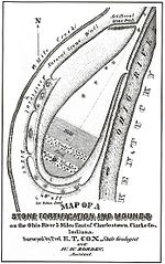
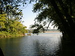
Rose Island is an abandoned amusement park near Charlestown, Indiana, situated on a peninsula (the "Devil's Backbone") created by Fourteen Mile Creek emptying into the Ohio River. It was a recreational area known as Fern Grove in the 1880s, mostly used as a church camp. It was so named due to the many ferns that grew there. The Louisville and Jeffersonville Ferry Company acquired it and developed it in order to increase the use of its ferry business. As Fern Grove it thrived on church picnics and family outings. The Great Depression hurt business, but its closure was due to damage caused by the 1937 Flood. Ten feet of water covered the park, and the damage was too much in order to rebuild for the 1937 season. Trees have fallen on the bridge and have destroyed all but the supports. Although covered with ivy, the swimming pool was still in excellent condition as late as 1980. Most of the buildings have left no trace, although a few brick formations remain.

Excerpt from the Wikipedia article Rose Island (amusement park) (License: CC BY-SA 3.0, Authors, Images).

Rose Island (amusement park)
Trail 7,

Geographical coordinates (GPS) Address Nearby Places
placeShow on map

Wikipedia: Rose Island (amusement park)Continue reading on Wikipedia

Geographical coordinates (GPS)

Latitude Longitude
N 38.430026 ° E -85.617185 °
placeShow on map

Address

Trail 7

Trail 7
40026
Indiana, United States
mapOpen on Google Maps

Rose Island crossing
Share experience

Nearby Places

Fourteen Mile Creek
Fourteen Mile Creek

Fourteen Mile Creek, shown as Fourteenmile Creek on federal maps, is a 22.7-mile-long (36.5 km) creek in Clark County, Indiana, close to Charlestown. It is so named because its mouth on the Ohio River is 14 miles (23 km) upstream from the Falls of the Ohio; similar to how Eighteen Mile Island, Twelve Mile Island, and Six Mile Island got their names. It is navigable for 2.9 miles (4.7 km) from the Ohio River. It is a State Heritage Program Site and a popular canoe trail. The creek was formed when glaciated water flowed through the unglaciated stream valley that is now the creek. It is lined by limestone cliffs, and the region is noted for its karst sinkholes, hidden waterfalls, and small caves. Due to the damming of the Ohio River, much of the creek is of the same elevation as the river. In fact, the creek sometimes appears to be flowing upstream when in fact rising waters from the Ohio push into the creek. Further upstream from the river, the creek is sometimes only a foot or two deep, which is why historically mills that used the creek had to use dams to keep a constant flow to run them. Bass, bluegill and catfish are the most common fish on the creek. The creek has seen much history. It is known that the Talligewi Indian tribe resided here. Many local mills used Fourteen Mile Creek for power, most especially Tunnel Mill. The popular Rose Island amusement park was situated where the creek and the Ohio River meet. During the time that the Indiana Army Ammunition Plant was in operation, the discharge of the Black Power Plant was treated by either a Sanitary Waste Treatment (SWT) plant or on Industrial Waste Treatment (IWT) Plant. Treated discharge from these plants, meeting all state and federal regulations and requirements, went into the Creek. Since the plant's demise, this is no longer a concern.