place

Mayfield Salisbury Church

Category B listed buildings in EdinburghChurch of Scotland churches in EdinburghHippolyte Blanc buildingsListed churches in EdinburghUse British English from March 2018
MayfieldSalisburyParishChurchCHAP

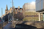
Mayfield Salisbury Church is a member of the Church of Scotland, part of the worldwide family of the Christian Church. It is situated approximately 1.5 miles (2.4 km) south of Edinburgh city centre at the junction of Mayfield Road and West Mayfield. The building was designed by the renowned Scottish architect, Hippolyte Blanc and the main building work took place between 1875 and 1879. It is particularly renowned for the range and quality of its stained glass. An extensive internal renovation of the sanctuary was undertaken in 2009.

Excerpt from the Wikipedia article Mayfield Salisbury Church (License: CC BY-SA 3.0, Authors, Images).

Mayfield Salisbury Church
West Mayfield, City of Edinburgh Newington

Geographical coordinates (GPS) Address External links Nearby Places
placeShow on map

Wikipedia: Mayfield Salisbury ChurchContinue reading on Wikipedia

Geographical coordinates (GPS)

Latitude Longitude
N 55.933083333333 ° E -3.1772027777778 °
placeShow on map

Address

Mayfield Salisbury Parish Church

West Mayfield
EH9 1TQ City of Edinburgh, Newington
Scotland, United Kingdom
mapOpen on Google Maps

linkWikiData (Q6797195)
linkOpenStreetMap (67524350)

MayfieldSalisburyParishChurchCHAP
Share experience

Nearby Places

Newington, Edinburgh

Newington is a neighbourhood of southern Edinburgh, Scotland. Developed from the early 19th century, it is an affluent, predominantly residential area. Located between 1 (1.5km) and 2.5 miles (4km) south of Edinburgh city centre, Newington is bounded to the east by St Leonard's and Prestonfield; to the south by Cameron Toll and Nether Liberton; to the west by Blackford, the Grange, and Sciennes; and to the north by the Southside, Edinburgh. Historically part of the parishes of St Cuthbert's and Liberton in the county of Midlothian, Newington was incorporated into the city of Edinburgh between 1832 and 1896.Originally part of the ancient forest of Drumselch, the lands of Newington were feued by the town council of Edinburgh from 1586. Aside from small developments, the area was predominantly rural until Benjamin Bell purchased the lands in 1805 and began to develop them as a suburb. Around this time, the construction of a new route from Edinburgh's New Town to Liberton via Newington was accelerating the southward development of the city. From the 1850s, bus services connected Newington to the city centre while trams arrived in 1871. Newington station opened to passengers in 1884. By this time, the area was almost enitrely developed. In the latter half of the 19th century, institutions including the Longmore Hospital, the Royal Blind Asylum, and St Margaret's School set up in Newington. Newington station closed to passengers in 1962. Northern Newington consists of dense early Victorian tenements and Georgian terraces. South of Salisbury Road, these give way to sparser, late Georgian and early Victorian developments, some of which were founded as gated communities. Southern Newington includes Victorian villas and terraces as well as some former industrial buildings. With a population of around 11,000, Newington today remains an affluent, primarily residential suburb. The area is also one of the most diverse in Edinburgh. Newington houses Edinburgh's only synagogue as well as the headquarters of Historic Environment Scotland and the Causewayside site of the National Library of Scotland.

St Leonard's, Edinburgh

St Leonard's is a neighbourhood of south-central Edinburgh, Scotland, United Kingdom. Once notable as a centre of industry, it is now primarily residential. The area takes its name from the mediaeval hospital of St Leonard, which stood on St Leonard's Hill on the edge of Holyrood Park. The hospital had fallen out of use by the mid-17th century but, by the middle of the following century, a small village had developed on the east side of the road between Edinburgh and Dalkeith. One prominent house built in this time, Hermits and Termits, survives. In 1831, the Edinburgh and Dalkeith Railway opened its northern terminus at St Leonard's. Later in the 19th century, businesses including Thomas Nelson & Sons publishers and J. & G. Stewart distillers established manufacturing operations in St Leonard's. Industry declined throughout the 20th century with the station and Nelson's Parkside Works closing in 1968. In this period, abortive plans to demolish much of the area in favour of a ring road led to "planning blight" and the destruction of many older properties. Since the 1970s, however, St Leonard's has been redeveloped as a residential neighbourhood. St Leonard's is the site of the University of Edinburgh's Pollock Halls of Residence, including the Confucius Institute of Scotland. The Royal Commonwealth Pool – used in the 1970, 1986 and 2014 Commonwealth Games – is located here, as is St Leonard's Police Station. Until 2020, Scottish Widows was headquartered in St Leonard's.