Pļavnieki
.jpg)
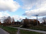
Pļavnieki is a Riga neighbourhood situated to the right of the river Daugava. Territory of the Pļavnieki for many centuries was used as agricultural land and was added to Riga only in 1974. The name "Pļavnieki" is derived from Latvian word "pļava" meaning meadow. Project of the new residential neighbourhood for 60,000 people was finished in 1978. Majority of the current residential buildings are built in 1980s. Pļavnieki is one of the most densely inhabited neighbourhoods in Riga. The total area of the Pļavnieki neighborhood is 2,985 km², which is approximately 2/5 less than the average neighborhood area in Riga. The length of the perimeter of the neighborhood borders is 7,664 meters. The boundaries of the Pļavnieki neighborhood in nature are clearly readable as they follow major roads. The current building structure in Pļavnieki largely differs from the building structure in neighboring neighborhoods. Pļavnieki is a densely populated neighborhood with predominantly 9 to 16-story buildings, as well as individual 18-story buildings.
Excerpt from the Wikipedia article Pļavnieki (License: CC BY-SA 3.0, Authors, Images).Pļavnieki
Andreja Saharova iela, Riga Pļavnieki
Geographical coordinates (GPS) Address Nearby Places Show on map
 Continue reading on Wikipedia
 Geographical coordinates (GPS)
| Latitude | Longitude |
|---|---|
| N 56.94 ° | E 24.207777777778 ° |
Address
Andreja Saharova iela
LV-1082 Riga, Pļavnieki
Vidzeme, Latvia
Open on Google Maps