place

Dunfermline Abbey

1128 establishments in ScotlandBenedictine monasteries in ScotlandBuildings and structures in DunfermlineBurial sites of the House of BruceCategory A listed buildings in Fife
Christian monasteries established in the 12th centuryChurch of Scotland churches in ScotlandFormer Christian monasteries in ScotlandHistoric Environment Scotland propertiesListed churches in ScotlandListed monasteries in ScotlandMuseums in DunfermlineProtestant churches converted from Roman CatholicismReligious buildings and structures completed in 1150Religious museums in ScotlandReligious organizations established in the 1120sRomanesque architecture in ScotlandRuined abbeys and monasteriesRuins in FifeScheduled Ancient Monuments in Fife
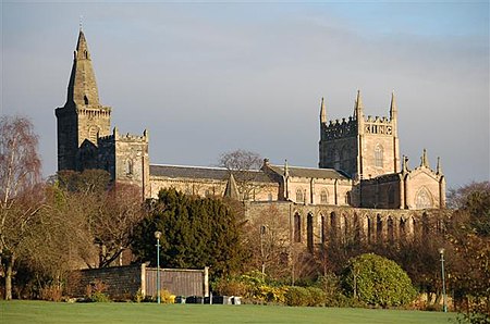
Dunfermline Abbey Geograph

Dunfermline Abbey is a Church of Scotland parish church in Dunfermline, Fife, Scotland. The church occupies the site of the ancient chancel and transepts of a large medieval Benedictine abbey, which was sacked in 1560 during the Scottish Reformation and permitted to fall into disrepair. Part of the old abbey church continued in use at that time and some parts of the abbey infrastructure still remain.

Excerpt from the Wikipedia article Dunfermline Abbey (License: CC BY-SA 3.0, Authors, Images).

Dunfermline Abbey
St Catherine's Wynd, Dunfermline Central Dunfermline

Geographical coordinates (GPS) Address External links Nearby Places
placeShow on map

Wikipedia: Dunfermline AbbeyContinue reading on Wikipedia

Geographical coordinates (GPS)

Latitude Longitude
N 56.0699 ° E -3.4636 °
placeShow on map

Address

Dunfermline Abbey

St Catherine's Wynd
KY12 7PH Dunfermline, Central Dunfermline
Scotland, United Kingdom
mapOpen on Google Maps

linkWikiData (Q2044924)
linkOpenStreetMap (122229504)

Dunfermline Abbey Geograph
Share experience

Nearby Places

Malcolm's Tower
Malcolm's Tower

Malcolm's Tower, also known as Malcolm Canmore's Tower, is a historic site in the Scottish city of Dunfermline, Fife. It consists of the foundations of a rubble built, rectangular tower enclosed by an oval shaped modern wall and is protected as a scheduled monument. It is located in Pittencrieff Park.The tower stood on a highly defensible peninsular outcrop of rock above a deep ravine and is the site from which the city derives its name. It was effectively the seat of royal power in Scotland after Malcolm III of Scotland shifted the centre of government from Forteviot to Dunfermline in the mid 11th century. The site was also close to a religious centre which had begun as a Culdee establishment in the 9th century. The first mention of the tower in the historical record is from 1070 when Malcolm III married his queen, Princess Margaret. As queen, Margaret introduced innovations which changed the course and identity of the Church in Scotland. Not far to the east of the tower's location are the remains of Dunfermline Abbey and later royal palace. All that survives of the tower today are foundational fragments of wall, but an image of the building was adopted at an early date as the burgh arms for Dunfermline. Old wax seals suggest it to have been a building of two storeys with an attic. It might have contained around twenty small apartments. Before the western access road to Dunfermline was built, Malcolm's Tower would have been an almost impregnable fortress, perhaps rather like a broch, and this almost certainly explains Dunfermline's motto Esto rupes inaccessa (Be an inaccessible rock).The opening lines of the traditional "Ballad of Sir Patrick Spens" are thought to refer to the tower: The King sits in Dunfermling Toun Drynking the bluid-red wyne …