Aragvi
Asia river stubsEurope river stubsGeorgia (country) geography stubsRivers of Georgia (country)Tributaries of the Kura (Caspian Sea)

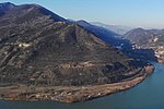
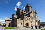
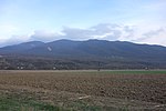
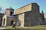
The Aragvi (Georgian: არაგვი) and its basin are in Georgia on the southern slopes of the Caucasus Mountains. The river is 112 kilometres (70 mi) long, and its basin covers an area of 2,740 square kilometres (1,060 sq mi). The ground strata are mostly sandstone, slate, and limestone. The Zhinvali Dam and its 130 MW hydro-electric power station generate much of Georgia's power, and its construction in 1986 formed the Zhinvali Reservoir, upon whose north-western shores rises Ananuri castle with its 17th-century Church of the Assumption.
Excerpt from the Wikipedia article Aragvi (License: CC BY-SA 3.0, Authors, Images).Aragvi
Arsukidze Street,
Geographical coordinates (GPS) Address Nearby Places Show on map
 Continue reading on Wikipedia
 Geographical coordinates (GPS)
| Latitude | Longitude |
|---|---|
| N 41.84003 ° | E 44.72611 ° |
Address
Arsukidze Street
3300
Mtskheta-Mtianeti, Georgia
Open on Google Maps