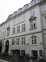
Lavendelstræde
Streets in Copenhagen

Lavendelstræde (lit. "Lavender Street") is a street in the old town of Copenhagen, Denmark). It runs from Kattesundet-Hestemøllestræde in the northeast to Vester Voldgade in the west, linking Slutterigade and Nytorv and at Regnbuepladsen and Copenhagen City Hall in the southwest.
Excerpt from the Wikipedia article Lavendelstræde (License: CC BY-SA 3.0, Authors, Images).Lavendelstræde
Lavendelstræde, Copenhagen Vesterbro
Geographical coordinates (GPS) Address Nearby Places Show on map
Geographical coordinates (GPS)
| Latitude | Longitude |
|---|---|
| N 55.6764 ° | E 12.5717 ° |
Address
Lavendelstræde 10
1462 Copenhagen, Vesterbro
Capital Region of Denmark, Denmark
Open on Google Maps


