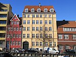
Dronningensgade
Streets in Christianshavn

Dronningensgade is a street in the Christianshavn district of Copenhagen, Denmark, running parallel to Christianshavn Canal one block to the east, from Christianshavn Rampart in the south to Bådsmandsstræde in the north.
Excerpt from the Wikipedia article Dronningensgade (License: CC BY-SA 3.0, Authors, Images).Dronningensgade
Dronningensgade, Copenhagen Christianshavn
Geographical coordinates (GPS) Address Nearby Places Show on map
Geographical coordinates (GPS)
| Latitude | Longitude |
|---|---|
| N 55.6724 ° | E 12.5926 ° |
Address
Dronningensgade 52
1420 Copenhagen, Christianshavn
Capital Region of Denmark, Denmark
Open on Google Maps


