place

Lachine Canal

Adaptive reuse of industrial structures in MontrealBike paths in QuebecCanal museumsCanals in QuebecCanals opened in 1825
Economic history of CanadaLaSalle, QuebecLachine, QuebecLe Sud-OuestNational Historic Sites in QuebecParks in MontrealRedeveloped ports and waterfronts in CanadaSaint Lawrence RiverSaint Lawrence SeawayTourist attractions in MontrealTransport in MontrealTransport museums in QuebecUse Canadian English from January 2023
Lachine canal
Lachine canal

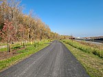
The Lachine Canal (canal de Lachine in French) is a canal passing through the southwestern part of the Island of Montreal, Quebec, Canada, running 14.5 kilometres (9 miles) from the Old Port of Montreal to Lake Saint-Louis, through the boroughs of Lachine, Lasalle and Sud-Ouest. Before the canal construction there was a lake, Lac St. Pierre or Lac à la Loutre (Montréal) or Petit Lac St. Pierre. The lake and its rivers can be seen on the maps of Montreal of the years 1700, 1744 and on the map titled "The isles of Montreal. As they have been surveyed by the French engineers" (1761). The lake is now filled in and located near the Turcot Interchange on Autoroute 20. The canal gets its name from the French word for China (la Chine). The European explorers sought to find a route from New France to the Western Sea, and from there to China and hence auspiciously the region where the canal was built was named Lachine. Due to the continuous disposal of industrial waste, the canal contains harmful substances, though the water quality is said to be good.

Excerpt from the Wikipedia article Lachine Canal (License: CC BY-SA 3.0, Authors, Images).

Lachine Canal
Rue Saint-Patrick, Montreal Le Sud-Ouest

Geographical coordinates (GPS) Address Nearby Places
placeShow on map

Wikipedia: Lachine CanalContinue reading on Wikipedia

Geographical coordinates (GPS)

Latitude Longitude
N 45.458333333333 ° E -73.611666666667 °
placeShow on map

Address

Rue Saint-Patrick 6328
H4E 4K4 Montreal, Le Sud-Ouest
Quebec, Canada
mapOpen on Google Maps

Lachine canal
Lachine canal
Share experience

Nearby Places

Saint-Jacques Escarpment

The Saint-Jacques Escarpment (French: Falaise Saint-Jacques) is a green space along an escarpment in the city of Montreal, west of downtown Montreal and adjacent to the neighbourhood of Notre-Dame-de-Grâce. The wooded area stretches 3 km (2 mi) long, covering over 20 ha (49 acres).The escarpment's dense stands of poplar trees and its location between Mount Royal and the Lachine Rapids make it notable for a number of species of resident and migratory birds and a large population of brown snakes.The land at the foot of the escarpment was previously known as a body of water named "Lac St-Pierre". The lake started losing its water with the opening of the Lachine Canal in the year 1825.The escarpment had served as a dumping ground before it was purchased by the City of Montreal for use as parkland, but until 2021 it was not open to the public. Plans to allow public access were frequently delayed because parts of the slope are unstable and dangerous, and the city's desire to preserve the escarpment as a natural space conflicted with the Province of Quebec's plans for redevelopment of the Turcot Interchange, which include moving the Ville-Marie Expressway and Canadian National Railway line next to the foot of the escarpment.In 2020, the city of Montreal announced a proposal to turn much of the space into a park that would stretch nearly 2 kilometres (1.2 mi).In 2021, the 2.7 kilometres (1.7 mi) long park was opened to the public. The west entrance is at Sainte-Anne de Bellevue Boulevard and Brock Avenue South. The east entrance is at Rue Pullman, just northwest of the Turcot Interchange.

Oxford Park, Montreal

Oxford Park (French: Parc Oxford) is a park in Montreal, Quebec, Canada. It is located in the southern part of the Notre-Dame-de-Grâce neighbourhood in the borough of Côte-des-Neiges–Notre-Dame-de-Grâce. While known informally as Oxford Park for many years, with activities operated by the Oxford Park Association, the City of Montreal formally named it the Georges-Saint-Pierre Park (French: Parc Georges-Saint-Pierre) during the 1990s in honour of the founder of the local Caisse Populaire Saint-Raymond, a community credit union. The park was made famous for its sporting tradition. Hockey greats as Doug Harvey, Howie Morenz, Kenny Mosdell and Fleming Mackell learned their crafts on the outdoor rink which was part of a larger neighbourhood house league, including such teams at Terrebonne Park, Benny Park, and Patricia Park. The park was also where boxing legend Johnny Greco played sports as a child. The park is bounded by Oxford, Upper Lachine, Old Orchard Avenue and Saint Jacques Street.The park was initially part of a farm owned by the Brodie clan, who bought the land after arriving from Scotland.After several generations the family sold to the city of Montreal in 1949 for $73,000 under the condition that the historic farmhouse would be turned into a library or facility for children. The city reneged on this clause and the stone building was demolished in the 1960s. The park was also home to a longstanding Italian Festival which was cancelled after the city added a controversial fenced-off plastic turf soccer field, which could get damaged during fireworks.