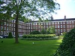
The Honourable Society of Gray's Inn, commonly known as Gray's Inn, is one of the four Inns of Court (professional associations for barristers and judges) in London. To be called to the bar in order to practise as a barrister in England and Wales, an individual must belong to one of these inns. Located at the intersection of High Holborn and Gray's Inn Road in Central London, the Inn is a professional body and provides office and some residential accommodation for barristers. It is ruled by a governing council called "Pension," made up of the Masters of the Bench (or "benchers,") and led by the Treasurer, who is elected to serve a one-year term. The Inn is known for its gardens (the “Walks,”) which have existed since at least 1597.
Gray's Inn does not claim a specific foundation date; none of the Inns of Court claims to be any older than the others. Law clerks and their apprentices have been established on the present site since at latest 1370, with records dating from 1381. During the 15th and 16th centuries, the Inn grew in size peaking during the reign of Elizabeth I. The Inn was home to many important barristers and politicians, including Francis Bacon. Queen Elizabeth herself was a patron. As a result of the efforts of prominent members such as William Cecil and Gilbert Gerard, Gray's Inn became the largest of the four Inns by number, with over 200 barristers recorded as members. During this period, the Inn mounted masques and revels. William Shakespeare’s The Comedy of Errors is believed first to have been performed in Gray’s Inn Hall.
The Inn continued to prosper during the reign of James I (1603–1625) and the beginning of that of Charles I, when over 100 students per year were recorded as joining. The outbreak of the First English Civil War in 1642 during the reign of Charles I disrupted the systems of legal education and governance at the Inns of Court, shutting down all calls to the bar and new admissions, and Gray's Inn never fully recovered. Fortunes continued to decline after the English Restoration, which saw the end of the then-traditional method of legal education. Now more prosperous, Gray's Inn is today the smallest of the Inns of Court.


