place

Rue de la Commune

Cobbled streetsOld MontrealStreets in Montreal
Delacommune
Delacommune

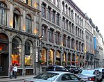
Rue de la Commune (English: De la Commune Street) is a road in Old Montreal which is well used both by Montrealers and by tourists, since it is the home of the Pointe-à-Callière Museum and the Old Port of Montreal. The road follows the original shore of the Saint Lawrence River. The buildings along the north side of the road are former commercial buildings.

Excerpt from the Wikipedia article Rue de la Commune (License: CC BY-SA 3.0, Authors, Images).

Rue de la Commune
Rue de la Commune Ouest, Montreal Ville-Marie

Geographical coordinates (GPS) Address Nearby Places
placeShow on map

Wikipedia: Rue de la CommuneContinue reading on Wikipedia

Geographical coordinates (GPS)

Latitude Longitude
N 45.505102 ° E -73.553235 °
placeShow on map

Address

Rue de la Commune Ouest 2
H2Y 2E1 Montreal, Ville-Marie
Quebec, Canada
mapOpen on Google Maps

Delacommune
Delacommune
Share experience

Nearby Places

Château Vaudreuil
Château Vaudreuil

Château Vaudreuil was a stately residence and college in Montreal, Quebec, Canada. It was constructed between 1723 and 1726 for Philippe de Rigaud, Marquis de Vaudreuil, as his private residence by Gaspard-Joseph Chaussegros de Léry. Though the Château Saint-Louis in Quebec City remained the official residence of the Governors General of New France, the Château Vaudreuil was to remain as their official home in Montreal up until the British Conquest in 1763. In 1767, it was purchased by the Marquis de Lotbinière. He sold it in 1773, when it became the Collège Saint-Raphaël. It was destroyed by a fire in 1803. Completed in 1726, it was built in the classical style of the French Hôtel Particulier by King Louis XV's chief engineer in New France, Gaspard-Joseph Chaussegros de Léry. The central building was flanked by two wings with two sets of semi-circular stairs leading up to a terrace and the main entrance. It stood beyond the end of Rue Saint-Paul, which was kept clear of buildings on that side to afford it a clear view, while formal gardens led up to Notre-Dame Street.Following the fire in 1803, a group of merchants, led by The Hon. Jean-Baptiste Durocher and The Hon. Joseph Périnault, purchased the land. On the condition that it would be used for public markets, they gave the government a small, oblong, strip of land (that had made up part of the formal gardens), which was first named New Market Place and from 1847 became known as Place Jacques-Cartier. This canny deal made by the merchants had the effect of increasing the value of the adjacent properties built around the 'square', which remained in private hands. In 1809, Nelson's Column was built by the citizens of Montreal in what had been part of the Château's formal gardens.