Rollins Dam

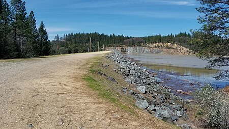
Rollins Dam (National ID # CA00255) is a dam on the border of Nevada and Placer counties in northern California, in the United States. The earthen dam was constructed in 1965 by the Nevada Irrigation District, with a height of 228 feet (69 m), and a length of 1,840 feet (560 m) at its crest. It impounds the Bear River, a tributary of the Feather River, for hydropower, flood control, irrigation water storage, and municipal water use. The dam is one of the ten facilities owned and operated by the Nevada Irrigation District. The dam is part of the Yuba-Bear Hydroelectric Project. The reservoir it creates, Rollins Reservoir, has a normal water surface of 1.3 square miles (3.4 km2), and a maximum capacity of 66,000 acre-feet. Recreation includes trout fishing in the spring, and bass fishing in the summer. The California Office Of Environmental Health Hazard Assessment has issued a safe eating advisory for any fish caught in Rollins Reservoir due to elevated levels of mercury.
Excerpt from the Wikipedia article Rollins Dam (License: CC BY-SA 3.0, Authors, Images).Rollins Dam
Old Bridge Road,
Geographical coordinates (GPS) Address Nearby Places Show on map
Geographical coordinates (GPS)
| Latitude | Longitude |
|---|---|
| N 39.13576 ° | E -120.95233 ° |
Address
Old Bridge Road
Old Bridge Road
95712
California, United States
Open on Google Maps


