Oroville Dam is an earthfill embankment dam on the Feather River east of the city of Oroville, California, in the Sierra Nevada foothills east of the Sacramento Valley. At 770 feet (235 m) high, it is the tallest dam in the U.S. and serves mainly for water supply, hydroelectricity generation, and flood control. The dam impounds Lake Oroville, the second-largest reservoir in California, capable of storing more than 3.5 million acre-feet (1.1×10^12 US gal; 4.3×10⁹ m3).Built by the California Department of Water Resources, Oroville Dam is one of the key features of the California State Water Project (SWP), one of two major projects passed that set up California's statewide water system. Construction was initiated in 1961, and despite numerous difficulties encountered during its construction, including multiple floods and a major train wreck on the rail line used to transport materials to the dam site, the embankment was topped out in 1967 and the entire project was ready for use in 1968. The dam began to generate electricity shortly afterwards with completion of the Edward Hyatt Power Plant, then the country's largest underground power station.
Since its completion in 1968, the Oroville Dam has allocated the flow of the Feather River from the Sacramento-San Joaquin Delta into the SWP's California Aqueduct, which provides a major supply of water for irrigation in the San Joaquin Valley, as well as municipal and industrial water supplies to coastal Southern California, and has prevented large amounts of flood damage to the area—more than $1.3 billion between 1987 and 1999. The dam stops fish migration up the Feather River and the controlled flow of the river; as a result, the Oroville Dam has affected riparian habitat. Multiple attempts at trying to counter the dam's impacts on fish migration have included the construction of a salmon/steelhead fish hatchery on the river, which began shortly after the dam was completed.
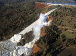
In February 2017, the main and emergency spillways threatened to fail, leading to the evacuation of 188,000 people living near the dam. After deterioration of the main spillway largely stabilized and the water level of the dam's reservoir dropped below the top of the emergency spillway, the evacuation order was lifted.The main spillway was reconstructed by November 1, 2018, and water releases were successfully tested, up to 25,000 cu ft/s (710 m3/s), during April 2019.


