Springfield Lake
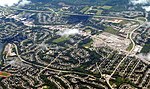
Springfield Lake is a small lake located in Middle Sackville, Halifax Regional Municipality. The shoreline perimeter is 5.6 km, the mean depth is 3 m and the maximum depth is 5 m (Mandaville 2000). Springfield is a headwater lake that is fed solely by underground springs and runoff. Located in the Shubenacadie watershed, it ultimately feeds into the Bay of Fundy. It lies in pyretic slate bedrock that is high in hydrogen and sulphur (Kerekes et al. 1986). The shoreline is fully developed (lined by private homes and cottages) with over 530 houses in the 500 ha watershed. Homes on streets adjacent to the lake receive municipal sewage treatment. There is a HRM Water Pollution Control Plant (secondary sludge activation), constructed in 1987, that discharges effluent into a stream outflowing at the north end of the lake. There is a public beach at the northwestern end of the Lake.
Excerpt from the Wikipedia article Springfield Lake (License: CC BY-SA 3.0, Authors).Springfield Lake
Lakeview Avenue, Halifax Regional Municipality
Geographical coordinates (GPS) Address Nearby Places Show on map
 Continue reading on Wikipedia
 Geographical coordinates (GPS)
| Latitude | Longitude |
|---|---|
| N 44.813055555556 ° | E -63.738055555556 ° |
Address
Lakeview Avenue 355
B4E 3B6 Halifax Regional Municipality, Daytona Park
Nova Scotia, Canada
Open on Google Maps