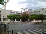
Fort de l'Est

Fort de l'Est is a military strong point designed to protect Paris. It was built between 1841 and 1843 in Saint-Denis at the direction of French prime minister Adolphe Thiers, and was part of an immense defensive belt comprising 17 detached forts and the Thiers Wall surrounding Paris. The evolution of artillery quickly made these fortifications obsolete. The fort is still used by the French Army. Units associated with the fort include a number of reserve units and the headquarters of the National Association of Reserve Warrant Officers. French Foreign Legion units associated with Operation Vigipirate are also stationed at Fort de l'Est. The northeast bastion of the formerly four-sided fort was removed to make way for the A1 autoroute, from which the fort is visible, and faces the Lycée Suger secondary school, built in 1994. The military files concerning military insubordinations of World War I in the French Army are preserved there, as well as some unclassified files from the library of the former garrison. The glacis of the fort is partly occupied by community gardens.
Excerpt from the Wikipedia article Fort de l'Est (License: CC BY-SA 3.0, Authors, Images).Fort de l'Est
Autoroute du Nord, Saint-Denis
Geographical coordinates (GPS) Address External links Nearby Places Show on map
Geographical coordinates (GPS)
| Latitude | Longitude |
|---|---|
| N 48.930555555556 ° | E 2.3722222222222 ° |
Address
Fort de l'Est
Autoroute du Nord
93200 Saint-Denis
Ile-de-France, France
Open on Google Maps


