place

Romer Shoal Light

1898 establishments in New JerseyLighthouses completed in 1898Lighthouses on the National Register of Historic Places in New JerseyNational Register of Historic Places in Monmouth County, New JerseyNew Jersey Register of Historic Places
Transportation buildings and structures in Monmouth County, New Jersey
Romer Shoal Light Station

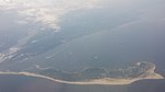
Romer Shoal Light is a sparkplug lighthouse in Lower New York Bay, on the north edge of the Swash Channel, about 3⁄4 nautical mile (1.4 km; 0.86 mi) south of Ambrose Channel and 2+1⁄2 nautical miles (4.6 km; 2.9 mi) north of Sandy Hook, New Jersey, in the entrance to New York Harbor. It is in New Jersey, very close to the border with New York. Named as Romer Shoal Light Station, it was added to the National Register of Historic Places on January 24, 2007, for its significance in architecture, engineering, transportation, and maritime history.

Excerpt from the Wikipedia article Romer Shoal Light (License: CC BY-SA 3.0, Authors, Images).

Romer Shoal Light
North Hartshorne Drive,

Geographical coordinates (GPS) Address External links Nearby Places
placeShow on map

Wikipedia: Romer Shoal LightContinue reading on Wikipedia

Geographical coordinates (GPS)

Latitude Longitude
N 40.513006388889 ° E -74.01352 °
placeShow on map

Address

Romer Shoal Light

North Hartshorne Drive

New Jersey, United States
mapOpen on Google Maps

linkWikiData (Q7363153)
linkOpenStreetMap (2576304642)

Romer Shoal Light Station
Share experience

Nearby Places

New York–New Jersey Harbor Estuary

The New York–New Jersey Harbor Estuary, also known as the Hudson-Raritan Estuary, is in the northeastern states of New Jersey and New York on the East Coast of the United States. The system of waterways of the Port of New York and New Jersey forms one of the most intricate natural harbors in the world and one of the busiest ports of the United States. The harbor opens onto the New York Bight in the Atlantic Ocean to the southeast and Long Island Sound to the northeast. Although the overall form of the estuary remains unchanged from the time of Giovanni da Verrazzano's visit in 1524, all parts have changed at least a little, and some parts, such as Hell Gate and Ellis Island, have been almost completely altered. In the greatest hidden change, the navigational channels have been deepened from the natural 17 feet (5.2 m) depth to 45 feet (14 m). In some places this required blasting of bedrock.There is an extremely complex system of tides and currents. Both the Bight and the Sound are essentially marine bodies with tides and saltwater, but the Sound compared to the Atlantic is about 20–30% less saline (as an estuary), and the tide is about 3 hours later with as much as 70% more variation. Rivers add a fresher, non-tidal inflow although the tide and brackishness extend well up rivers throughout the extended hydrologic system from Albany to Montauk Point to the Hudson Canyon region of the New York Bight. The New York Harbor Observing and Prediction System (NYHOPS) utilizes information from sensors, weather forecasts, and environment models to provide real-time forecasts of meteorological and oceanographic conditions in the area. Since the Ash Wednesday Storm of 1962 beaches along the shores of the East Coast have been regularly replenished with sand pumped in from off-shore. The United States Army Corps of Engineers (USACE) coordinates the projects.In 2016, USACE and the Port Authority of New York and New Jersey produced a comprehensive restoration plan for the New York Harbor region, with proposals to mitigate the effects of sea level rise through projects to restore natural areas. In September the USACE released the New York New Jersey Harbor and Tributaries Study (HATS).

Marine Academy of Science and Technology

The Marine Academy of Science and Technology (MAST) is a coeducational four-year magnet public high school located in the Sandy Hook section of Middletown Township, in Monmouth County, New Jersey, United States, serving students in ninth through twelfth grade. The school offers learning in all subjects, specializing in marine technology and science. It is one of five career academies administered by the Monmouth County Vocational School District (MCVSD). MAST requires each student to participate in the Naval Junior Reserve Officers' Training Corps (NJROTC) every year as well as an Annual Military Inspection (AMI) in the spring or fall. The school's curriculum focuses on marine sciences and marine technology/engineering. The school offers small classes with close personal attention. As of the 2021–22 school year, the school had an enrollment of 269 students and 26.0 classroom teachers (on an FTE basis), for a student–teacher ratio of 10.3:1. There were 2 students (0.7% of enrollment) eligible for free lunch and 1 (0.4% of students) eligible for reduced-cost lunch.The school is accredited by the Middle States Association of Colleges and Schools Commission on Elementary and Secondary Schools. The Marine Academy is a member of the National Consortium for Specialized Secondary Schools of Mathematics, Science and Technology. For the 1997–98 and 2013 school years, the Marine Academy was designated a Blue Ribbon School by the United States Department of Education. MAST was selected by the Department of Education as a New American High School for the 1998–99 school year; among the many honors and awards the innovative program has received throughout its years. On April 15, 2007, in honor of the Marine Academy's 25th Anniversary, a proclamation by the Monmouth County Board of Chosen Freeholders declared April 15 as "Marine Academy of Science and Technology Day" in Monmouth County.