place

Pispala

Districts of Tampere
Pispala Pyhäjärveltä 1

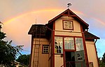
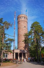
Pispala is a city area 2.5 km from the centre of Tampere, Finland. It is located on the northern slope of Pispalanharju, the highest esker in Finland. Together with Pyynikki, Pispala is widely considered the most beautiful area of Tampere and tourists are often guided there for the view and the unique urban design features of the area. A monument to the Finnish poet Lauri Viita is located near the highest point of the ridge and there is a famous landmark in the area called the Shot tower (Finnish: Pispalan haulitorni.).

Excerpt from the Wikipedia article Pispala (License: CC BY-SA 3.0, Authors, Images).

Pispala
Pispalan valtatie, Tampere Pispala (Läntinen suuralue)

Geographical coordinates (GPS) Address Nearby Places
placeShow on map

Wikipedia: PispalaContinue reading on Wikipedia

Geographical coordinates (GPS)

Latitude Longitude
N 61.5061 ° E 23.7025 °
placeShow on map

Address

Pispalan valtatie 65
33250 Tampere, Pispala (Läntinen suuralue)
Finland
mapOpen on Google Maps

Pispala Pyhäjärveltä 1
Share experience

Nearby Places

Hyhky
Hyhky

Hyhky (Swedish: Hycky or Hyhkö) is a district in the northwestern part of Tampere, Finland. It is bordered on the north by Lielahti, on the east by Ala-Pispala, on the south by Kaarila and on the west by Epilä. The village of Hyhky, which originally belonged to Pirkkala, was mentioned in documents as early as 1433. The first mention of Pispala dates back to 1492, when the boundary of the premises of Mikko Pispala and Niilo Huovari was checked. In fact, Pispala is named after Pispa's farm in Hyhky. In the Middle Ages, Hyhky was often a court seat, and at least in 1507, 1509, and 1514 lawspeaker courts were held there. According to the 1540 land register, Hyhky had seven farms. The origin of the name Hyhky is unknown, but the same roots are possibly Hykky in Pälkäne and Hykkö in Tyrvää. Hyhky was transferred from the then Northern Pirkkala to the city of Tampere at the beginning of 1937. The joint town plan of the Hyhky, Kaarila and Epilä districts was confirmed in 1953. The oldest building in Hyhky is known to be the old court house where the Henneri's playground currently operates. Henneri is an old house in the village of Hyhky and the name is probably based on the personal name Henrik. Hyhky also has a primary school. The Pispala timber rafting tunnel, built in the 1930s for log driving in the Kokemäki River, is located in Hyhky. The tunnel was preceded by two roller tracks (“red” and “gray” block road) located on the upper ridge. The new floating tunnel built next to the old floating tunnel was completed in 1968, but it was immediately redundant when the Kokemäki River's log driving ended at the end of the same year. In June 2013, the floating tunnel was opened for boat and pedestrian traffic as a connection between Lake Näsijärvi and Lake Pyhäjärvi.

Tahmela
Tahmela

Tahmela is a district in Tampere, Finland. It is located between Ylä-Pispala and Pyynikki on the shores of Lake Pyhäjärvi. There is a Varala Sports College in Tahmela. There are rental agricultural plots on the shore of Tahmela, and Kurpitsaliike ry ("the Pumpkin Movement") was founded in 1998 to defend the continuation of land cultivation in Tahmela.Tahmela has a large spring with very clear water until the 1960s, from which more than 600 households in the Pispala and Tahmela areas obtained their drinking water. The water was distributed by a cooperative that operated until 1961. In addition to the spring, the cultural center Hirvitalo is located in Tahmela. Tahmela is named after a croft of the same name located in the area, built around 1870. The croft was located along the current Selininkatu street. Tahmela was transferred from the municipality of Northern Pirkkala to the city of Tampere at the beginning of 1937. Until then, it had been part of the densely populated municipal community of Pispala. The town plan of Tahmela was confirmed in 1945 at the same time as the town plan of Pispala. The poet Yrjö Jylhä lived in Tahmela in his youth and according to him one of the streets of the district has been named. The former name of the Tahmela Bypass (Tahmelan viertotie) in 1945–1978 was Valtakunnantie and then until 1996 the Tahmela Highway (Tahmelan valtatie). The names refer, on the one hand, to a group of houses known as the "Kingdom of Vuorenmaa", and, on the other hand, that the street was to be built as a highway, like the Paasikiventie north of Pispala, under the Pyynikki Ridge's tunnel. Near Vallikatu are the remains of fortresses built by the Russian army during the First World War, which stretched from Tahmela to the Pispala Ridge. The name Hopankatu derives from a nearby ski jumping hill, built in 1908 and demolished in the late 1980s.

Lentävänniemi
Lentävänniemi

Lentävänniemi (Finnish pronunciation: [ˈle̞n̪t̪æʋænːie̯mi]) is a district in the western part of Tampere on the shores of Lake Näsijärvi in Pirkanmaa, Finland. It belongs to the northwestern part of the city and borders the Niemi and Niemenranta borders on the southwest. There are jogging paths along the lake and its shores surrounding the apartment-based Lentävänniemi. In 2014, the population of Lentävänniemi was 4,309.Lentävänniemi originally belonged to the municipality of Ylöjärvi, from where it was transferred to the city of Tampere in the early 1950s. The first town plan for Lentävänniemi was completed in 1966, and the entire area was zoned in 1974. Most of the street names in Lentävänniemi are group names related to navigating the waters according to the location of the place (such as Airokatu, Venekatu and Majakkakatu). Jänissaarenkatu, Jänislahdenkatu, Jänislammenkatu and Suomensaarenkatu are based on natural names. The former island of Suomensaari in Lake Näsijärvi, which grew close to the mainland as a peninsula, had a croft on Suomensaari in the early 19th century. Bus lines 3 and 14 run from Lentävänniemi to the city center of Tampere, about nine kilometers away. In addition, line 36 runs to Tampere University Hospital. Lentävänniemi has a school for grades 1-6, a kindergarten, a pizzeria, a barbecue kiosk, a sports field, a small shopping center with a pub, hairdresser, kebab restaurant, K-Market grocery store, and youth center, as well as two harbors, one of which is Jänissaari, which serves as the Näsijärvi Sailing Club. The Lentävänniemi library, which operated in the same building as the Lentävänniemi school, was merged with the Lamminpää library in the Lielahtikeskus, which was completed in 2014, into the Lielahti library.In the second phase of Tampere tram traffic, a light rail connection to Lentävänniemi would be established from the city center.

Pyynikki Esker
Pyynikki Esker

The Pyynikki Esker (or the Pyynikki Ridge; Finnish: Pyynikinharju) is the tallest longitudinal esker in the world, located in Pyynikki, Tampere, Finland. The ridge rises to a height of 160 meters above sea level and 80 meters above the surface of Lake Pyhäjärvi. The Pyynikki Esker belongs to the ridge formation that extends from South Ostrobothnia to Salpausselkä. The ridge formation continues west of the Pyynikki Esker as a rocky ridge known as the Pispala Esker (Pispalanharju) and Tahmela. To the east, after the settlement of Tampere, the ridge becomes the Kalevankangas esker, where there has been a cemetery by same name for almost 150 years. In Kangasala, the ridge formation continues as the four ridges called Kirkkoharju, Kuohunharju, Keisarinharju and Vehoniemenharju. The Pyynikki Esker, like longitudinal ridges, is mainly gravel and sand. There are still some old European red pines growing in Pyynikki, whose roots are partly in the air, as the sandy ground rolls down towards Lake Pyhäjärvi over the years. Vegetation on gravel ridges has not only pines but also junipers that are protected. However, juniper berries can be picked when you remember that the branches should not be folded or the juniper should not be removed from the ground. There also grows Norway maples, which give the ridge a beautiful color in autumn. Mountain currants also grow on these ridges. In the middle of the heathers you can find golden chanterelles and in the autumn a few other edible mushrooms. Lingonberries also thrive on the southern slopes.The Pyynikki observation tower, built in 1929, is still in use. It has a ground-level café. There are wooden stairs at several points on the slopes of Pyynikki, along which you can reach the top of the Pyynikki Esker from the shore of Lake Pyhäjärvi.

Paasikiven–Kekkosentie

Paasikiven–Kekkosentie ("Paasikivi–Kekkonen Road"), or Rantaväylä, is a busy car traffic route located in Tampere, Finland, which serves as a regional transit road and a significant access route to the city center. It is a four-lane highway owned by the Finnish state and part of Highway 12. Paasikiven–Kekkosentie is located between the Nokia's motorway and the Teiskontie street junction.The originally Paasikiven–Kekkosentie was seven kilometers long and was built in several phases. The first part was completed on the southern shore of Lake Näsijärvi and north of Tampere's city center in the mid-1970s. The last part at the Petsamo district was opened to traffic in 1989. At the planning stage, the highway was called Kehätie ("Ring Road"), but later the western part was named Paasikiventie and the eastern part Kekkosentie in the town plan. Paasikiventie changed to Kekkosentie on the shore of Tammerkoski at the eastern end of the Näsinsilta bridge.The name Paasikiventie refers to President J. K. Paasikivi, who lived in Tampere as an early child. When the street name was entered in the town plan in the early 1970s, one hundred years had passed since Paasikivi was born. The name Kekkosentie, which was included in the town plan in 1977, is intended to honor President Urho Kekkonen, who had connections to Tampere through businessman Kalle Kaihari. At the time of the completion of Paasikiven–Kekkosentie, the so-called Paasikivi–Kekkonen doctrine prevailed in Finnish foreign policy.Paasikiventie and Kekkosentie were originally streets managed and operated by the city, but in the mid-1990s they were converted into state-maintained public roads. The road section between Mustanlahti and Naistenlahti was widened in 1997. Completed in 2016, the Tampere Tunnel, which is a couple of kilometers long, changed the alignment of the fairway so that Paasikiventie is now located on the west side of the tunnel (west of Santalahti) and Kekkosentie on the east side of the tunnel (east of Naistenlahti). The tunnel section is not Paasikiventie or Kekkosentie, but the name of the underground road is Rantatunneli. With the tunnel, the above-ground road section between Santalahti and Naistenlahti became obsolete from Highway 12, and was renamed Paasikivenkatu–Kekkosenkatu. The word katu (translated "street") tells that the responsibility for maintaining the road lies with the city of Tampere.

Viikinsaari
Viikinsaari

Viikinsaari is an island located in the lake Pyhäjärvi belonging to the City of Tampere, Finland. The island is a popular nature resort and an outdoor recreation area, attracting visitors all year round. In the summertime there is a boat connection to the island from the Laukontori harbour. In winter, the island can be reached by walking or skiing. The western part is a nature reserve, but there are also swimming shores, playgrounds, a small chapel, a fireplace for roasting sausages, a restaurant, a footpath through the nature reserve and a dance pavilion on the island. Viikinsaari is administrated by the Tampere Culture Affairs, which organises happenings and events throughout summer for people in all ages, for example nature tours for children, dance lessons and events and music nights. It is also possible to rent a rowing boat, fishing rods, miniature golf equipment and there's a selection of games that can be borrowed from the Info office, including petanque, croquet, badminton, darts, football, volleyball and board games. Part of the events are organised by the private ferry company Suomen Hopealinja and the restaurant Wanha Kaidesaari. The first mentions about Viikinsaari date back to 1596. Until the 19th century the island was known as Kaidesaari, but the name was changed when the island became property of the Viikki Manor. The confectioner Carl Gustav Tallqvist opened a restaurant on the island first in 1866 and had a boat built to start a ferry service from the land. He later bought the islands from Viikki mansion, in the year 1881. After Tallqvist's death the island was deserted for some time. It was at the most used for herding until the City of Tampere bought it in 1893. After the restaurant had burnt down twice, the city architect Lambert Petterson designed the building in 1900 that is still in use today. Also a small jail was built on the island, which was altered into a chapel of East and West in 1995 and is a piece of art itself, designed by Ilkka Väätti. Viikinsaari has mostly been in use of the working class as their recreation space since the early 20th century. After some quieter years in the latter half of last century, the island is again in active use and attentively maintained. The price for a round trip by a ferry from Laukontori is 16 euros for adults, 10 euros for children (4-17), 8 euros for students and pensioners and with 35 euros it's possible to have a family ticket for 2 adults and 4 kids. Tickets can be bought from the ticket kiosk at Laukontori harbour or online for a discount.