place

Christchurch Central City

Central business districts in New ZealandChristchurch Central CityEconomy of ChristchurchEngvarB from July 2019Geography of Christchurch
Populated places established in 1850
Christchurch Square (Christchurch, New Zealand)

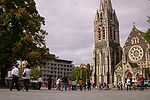
Christchurch Central City or Christchurch City Centre is the geographical centre and the heart of Christchurch, New Zealand. It is defined as the area within the Four Avenues (Bealey Avenue, Fitzgerald Avenue, Moorhouse Avenue and Deans Avenue) and thus includes the densely built up central city, some less dense surrounding areas of residential, educational and industrial usage, and green space including Hagley Park, the Christchurch Botanic Gardens and the Barbadoes Street Cemetery. It suffered heavy damage in the 2010 Canterbury earthquake and was devastated in the 2011 Christchurch earthquake. Following this second earthquake, the Central City Red Zone was set up and, with a gradually shrinking area, remained inaccessible except to authorised contractors until June 2013. However, proposals to relocate the city centre elsewhere, to avoid future damage, were considered both uneconomical (as much of the infrastructure was still mainly intact) and unnecessary, as the rebuilt city centre would be to modern building standards so as to be able to withstand similar quakes and liquefaction in the future.

Excerpt from the Wikipedia article Christchurch Central City (License: CC BY-SA 3.0, Authors, Images).

Christchurch Central City
Linwood-Central-Heathcote Community Central City

Geographical coordinates (GPS) Address Nearby Places
placeShow on map

Wikipedia: Christchurch Central CityContinue reading on Wikipedia

Geographical coordinates (GPS)

Latitude Longitude
N -43.531 ° E 172.6365 °
placeShow on map

Address

ChristChurch Cathedral (Christ Church Cathedral)


8011 Linwood-Central-Heathcote Community, Central City
Canterbury, New Zealand
mapOpen on Google Maps

Christchurch Square (Christchurch, New Zealand)
Share experience

Nearby Places

ChristChurch Cathedral

ChristChurch Cathedral, also called Christ Church Cathedral and (rarely) Cathedral Church of Christ, is a deconsecrated Anglican cathedral in the city of Christchurch, New Zealand. It was built between 1864 and 1904 in the centre of the city, surrounded by Cathedral Square. It became the cathedral seat of the Bishop of Christchurch, who is in the New Zealand tikanga of the Anglican Church in Aotearoa, New Zealand and Polynesia. Earthquakes have repeatedly damaged the building (mostly the spire): in 1881, 1888, 1901, 1922, and 2010. The February 2011 Christchurch earthquake destroyed the spire and the upper portion of the tower, and severely damaged the rest of the building. A lower portion of the tower was demolished immediately following the 2011 earthquake to facilitate search and rescue operations. The remainder of the tower was demolished in March 2012. The badly damaged west wall, which contained the rose window, partially collapsed in the June 2011 earthquake and suffered further damage in the December 2011 earthquakes. The Anglican Church decided to demolish the building and replace it with a new structure, but various groups opposed the church's intentions, with actions including taking a case to court. While the judgements were mostly in favour of the church, no further demolition occurred after the removal of the tower in early 2012. Government expressed its concern over the stalemate and appointed an independent negotiator and in September 2017, the Christchurch Diocesan Synod announced that ChristChurch Cathedral will be reinstated after promises of extra grants and loans from local and central government. By mid-2019 early design and stabilisation work had begun.Since 15 August 2013 the cathedral community has worshipped at the Cardboard Cathedral.

Fisher's Building
Fisher's Building

The Fisher's Building (also known as the Hanafins Building) was a 19th-century Venetian Gothic building located in central Christchurch, New Zealand. It was designed in 1872 by architect William Armson and constructed from concrete and brick in 1880 on a central city site leased to Thomas Richard Fisher, who ran a tea and grocery store. The building was known for its prominent verandah, ornate design, and distinct corner shape. A category-one heritage-listed property, the Fisher's Building was one of the few surviving examples of Venetian Gothic architecture in Christchurch. It was also the last surviving structure on Hereford Street designed by Armson, who had designed several commercial buildings in the area. Built as an extension to what was then the City Chambers, it occupied a corner site on the intersection of High Street and Hereford Street, giving it a distinctive triangle shape from above. Following Fisher's death in 1890, the building was inherited by his estate and passed to numerous owners in the subsequent decades, until it was purchased in 1922 by Henry Slater Richards, who transferred it to his three sons in 1926. The brothers held joint interest until the 1970s, when it was transferred to Pyne Gould Guinness Limited in 1979 following a successful restoration project. In 1929, the building became associated with James George Hanafin, who operated a chemist from property. In the 1980s, his descending relative Lawry Hanafin opened a photography store from the property, operating it for 30 years as one of the last tenants to run a business from the site. Despite being strengthened and well cared for, the Fisher's Building was badly damaged in the 2011 Christchurch earthquake. It was demolished in July 2011, with Hanafin watching the demolition. As of 2024, the site has remained empty and is used for car parking.