place

Black Tor Ferry

Cornwall stubsFerry stubsFerry transport in EnglandWater transport in Cornwall
Padstow Rock Ferry
Padstow Rock Ferry

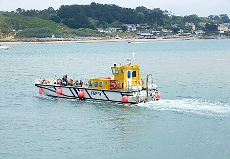
The Black Tor Ferry, also known as the Padstow to Rock Ferry, is a passenger ferry which crosses the tidal River Camel in north Cornwall, United Kingdom. The ferry carries pedestrians and cyclists only (not vehicles).

Excerpt from the Wikipedia article Black Tor Ferry (License: CC BY-SA 3.0, Authors, Images).

Black Tor Ferry
Dennis Road,

Geographical coordinates (GPS) Address Nearby Places
placeShow on map

Wikipedia: Black Tor FerryContinue reading on Wikipedia

Geographical coordinates (GPS)

Latitude Longitude
N 50.5384 ° E -4.9378 °
placeShow on map

Address

Dennis Road 16
PL28 8DE
England, United Kingdom
mapOpen on Google Maps

Padstow Rock Ferry
Padstow Rock Ferry
Share experience

Nearby Places

Tregirls
Tregirls

Tregirls (Cornish: Tregryllas, meaning farmstead of the ruins of an ancient dwelling) is a farmstead in Cornwall, United Kingdom. It is situated approximately half-a-mile (1 km) north of Padstow. The settlement consists of a farm and converted cottages which are let as holiday accommodation.Tregirls beach (which takes its name from the settlement) is 500 metres north at grid reference SW 911 769. The north-facing beach is in the River Camel estuary and is backed by dunes with a small stream trickling across the sand at low tide from the corner of the beach tucked hard behind Stepper Point known as Harbour Cove. Beyond Harbour Cove towards Stepper Point is Hawkers Cove, previously the location of the RNLI Padstow lifeboat, now too shallow even at high tide and dry sand at low tide, the result of the sands shifting over the years. The South West Coast Path runs behind the beach before climbing above the rocky side of the river at Hawkers Cove on its way to the Daymark on Stepper Point. Today at low water Tregirls beach extends half-a-mile into the estuary and at its northeast point forms the Doom Bar, a spit of sand across the river mouth. However this was not always so as the deep water channel used to run close to Stepper Point, as is evidenced by the old lifeboat station being located at Harbour Cove. The settlement of Tregirls takes its name from the manor of Grylls or Tregrylls of which it was a parcel along with Crugmeer, Treator, and Trenio.

Brea Hill
Brea Hill

Brea Hill (Cornish: Bre, meaning hill), pronounced "Bray Hill" is a round hill beside the River Camel estuary in north Cornwall, England, United Kingdom The hill is 62 metres (203 ft) high and there are Bronze Age tumuli (burial mounds) at the summit. The underlying geology in this area of Cornwall is Devonian slates. Brea Hill is situated at the south end of Daymer Bay between the settlements of Trebetherick and Rock in the civil parish of St Minver Lowlands. approximately five miles northwest of WadebridgeOn the west side, Brea Hill rises straight from the foreshore; on the north and south it rises from low sand dunes. To the east, the dunes give way to a golf course and grassland with St Enodoc's Church (where the poet Sir John Betjeman is buried) just below the hill. Brea Hill is within the Rock Dunes SSSI (Site of Special Scientific Interest). The reason that Brea Hill is such a positive feature in the landscape is that the centre of the hill, west to east, is a dolerite dyke, well-seen from the beach on the west and in the quarry on the east slope and in both exposures soft-sediment deformation is seen implying the intrusion followed shortly after deposition of the material which later became slate during the Variscan Orogeny. The dyke is shown on the British Geological Survey map Sheets 335 and 336, and memoir, for the Geology around Trevose Head and Camelford. The South West Coast Path follows the west flank of the hill with an alternative route passing to the east. Brea Hill is grassed and treeless (except for a small wooded area low on the south flank) with rough footpaths leading to the summit and burial mounds.

Doom Bar
Doom Bar

The Doom Bar (previously known as Dunbar sands, Dune-bar, and similar names) is a sandbar at the mouth of the estuary of the River Camel, where it meets the Celtic Sea on the north coast of Cornwall, England. Like two other permanent sandbanks further up the estuary, the Doom Bar is composed mainly of marine sand that is continually being carried up from the seabed. More than 60 percent of the sand is derived from marine shells, making it an important source of agricultural lime, which has been collected for hundreds of years; an estimated 10 million tons of sand or more has been removed from the estuary since the early nineteenth century, mainly by dredging. The estuary mouth, exposed to the Atlantic Ocean, is a highly dynamic environment, and the sands have been prone to dramatic shifts during storms. According to tradition, the Doom Bar formed in the reign of Henry VIII, damaging the prosperity of the port of Padstow a mile up the estuary. Until the twentieth century, access to Padstow's harbour was via a narrow channel between the Doom Bar and the cliffs at Stepper Point, a difficult passage for sailing ships to navigate, especially in north-westerly gales when the cliffs would cut off the wind. Many ships were wrecked on the Doom Bar, despite the installation of mooring rings and capstans on the cliffs and quarrying away part of Stepper Point to improve the wind. In the early twentieth century the main channel moved away from the cliffs, and continued dredging has made it much safer for boats, but deaths have occurred on the bar as recently as May 2020.A Cornish folklore legend relates that a mermaid created the bar as a dying curse on the harbour after she was shot by a local man. The Doom Bar has been used in poetry to symbolise feelings of melancholy, and has given its name to the flagship ale from the local Sharp's Brewery.