place

Key Bridge (Washington, D.C.)

1923 establishments in VirginiaBridges completed in 1923Bridges of the United States Numbered Highway SystemBridges over the Potomac RiverBuildings and structures in Arlington County, Virginia
Concrete bridges in the United StatesGeorgetown (Washington, D.C.)Harv and Sfn no-target errorsHistoric American Engineering Record in Washington, D.C.National Register of Historic Places in Arlington County, VirginiaNeoclassical architecture in VirginiaNeoclassical architecture in Washington, D.C.Open-spandrel deck arch bridges in the United StatesRoad bridges in VirginiaRoad bridges in Washington, D.C.Road bridges on the National Register of Historic Places in VirginiaRoad bridges on the National Register of Historic Places in Washington, D.C.Transportation in Arlington County, VirginiaU.S. Route 29Use mdy dates from September 2019
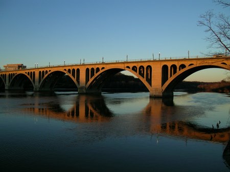
Key Bridge, Washington D.C

The Francis Scott Key Bridge, more commonly known as the Key Bridge, is a six-lane reinforced concrete arch bridge conveying U.S. Route 29 (US 29) traffic across the Potomac River between the Rosslyn neighborhood of Arlington County, Virginia, and the Georgetown neighborhood of Washington, D.C. Completed in 1923, it is Washington's oldest surviving road bridge across the Potomac River. Key Bridge was added to the National Register of Historic Places in 1996.

Excerpt from the Wikipedia article Key Bridge (Washington, D.C.) (License: CC BY-SA 3.0, Authors, Images).

Key Bridge (Washington, D.C.)
Francis Scott Key Bridge, Washington Georgetown

Geographical coordinates (GPS) Address External links Nearby Places
placeShow on map

Wikipedia: Key Bridge (Washington, D.C.)Continue reading on Wikipedia

Geographical coordinates (GPS)

Latitude Longitude
N 38.902222222222 ° E -77.070277777778 °
placeShow on map

Address

Key Bridge

Francis Scott Key Bridge
20057 Washington, Georgetown
District of Columbia, United States
mapOpen on Google Maps

linkWikiData (Q2688414)
linkOpenStreetMap (435842740)

Key Bridge, Washington D.C
Share experience

Nearby Places

Georgetown Car Barn
Georgetown Car Barn

The Georgetown Car Barn, historically known as the Capital Traction Company Union Station, is a building in the Georgetown neighborhood of Washington, D.C., in the United States. Designed by the architect Waddy Butler Wood, it was built between 1895 and 1897 by the Capital Traction Company as a union terminal for several Washington and Virginia streetcar lines. The adjacent Exorcist steps, later named after their appearance in William Friedkin's 1973 horror film The Exorcist, were built during the initial construction to connect M Street with Prospect Street. Intended for dual use as a passenger station and as a storage house for the streetcars, the Car Barn began Washington's only cable car system. Almost immediately after the building opened, the system was electrified, and the Car Barn was converted to accommodate electric streetcars. Throughout its history as a terminal and storage facility, the Car Barn was never utilized to the extent anticipated by its construction. The building has undergone several renovations, the most extensive in 1911, when the original Romanesque Revival façade was significantly modified, and the interior was almost completely gutted. Not long after its opening, the building fell into disrepair. Changing ownership over time, it maintained its original function of housing streetcars until 1950, when it was redeveloped as office space. Among its occupants was the International Police Academy, an arm of the Central Intelligence Agency, which operated out of the Car Barn in the 1960s and 1970s. Today, it is used as an academic building by Georgetown University. In 2019, it was listed on the National Register of Historic Places.