place

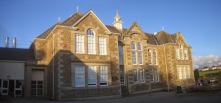
Humphry Davy School

1910 establishments in EnglandBuildings and structures in PenzanceCornwall building and structure stubsCornwall organisation stubsEducational institutions established in 1910
Foundation schools in CornwallSecondary schools in CornwallSouth West England school stubsSpecialist music colleges in EnglandUse British English from February 2023
Humphry Davy School
Humphry Davy School

Humphry Davy School is a comprehensive school in Penzance, Cornwall, England. The school teaches 11 to 16-year-olds.

Excerpt from the Wikipedia article Humphry Davy School (License: CC BY-SA 3.0, Authors, Images).

Humphry Davy School
Tremenheere Road,

Geographical coordinates (GPS) Address Nearby Places
placeShow on map

Wikipedia: Humphry Davy SchoolContinue reading on Wikipedia

Geographical coordinates (GPS)

Latitude Longitude
N 50.1242 ° E -5.54089 °
placeShow on map

Address

Tremenheere Road
TR18 2AH , Treneere
England, United Kingdom
mapOpen on Google Maps

Humphry Davy School
Humphry Davy School
Share experience

Nearby Places

Penzance
Penzance

Penzance ( pen-ZANSS; Cornish: Pennsans) is a town, civil parish and port in the Penwith district of Cornwall, England, United Kingdom. It is the most westerly major town in Cornwall and is about 64 miles (103 km) west-southwest of Plymouth and 255 miles (410 km) west-southwest of London. Situated in the shelter of Mount's Bay, the town faces south-east onto the English Channel, is bordered to the west by the fishing port of Newlyn, to the north by the civil parish of Madron and to the east by the civil parish of Ludgvan. The civil parish includes the town of Newlyn and the villages of Mousehole, Paul, Gulval, and Heamoor. Granted various royal charters from 1512 onwards and incorporated on 9 May 1614, it has a population of 21,200 (2011 census).Penzance's former main street Chapel Street has a number of interesting features, including the Egyptian House, The Admiral Benbow public house (home to a real life 1800s smuggling gang and allegedly the inspiration for Treasure Island's "Admiral Benbow Inn"), the Union Hotel (including a Georgian theatre which is no longer in use), and Branwell House, where the mother and aunt of the famous Brontë sisters once lived. Regency and Georgian terraces and houses are common in some parts of the town. The nearby sub-tropical Morrab Gardens has a large collection of tender trees and shrubs, many of which cannot be grown outdoors anywhere else in the UK. Also of interest is the seafront with its promenade and the open-air seawater Jubilee Pool (one of the oldest surviving Art Deco swimming baths in the country). Penzance is the base of the pirates in Gilbert and Sullivan's comic opera The Pirates of Penzance. At the time the libretto was written, 1879, Penzance had become popular as a peaceful resort town, so the idea of it being overrun by pirates was amusing to contemporaries.

Penwith Hundred
Penwith Hundred

Penwith Hundred was one of ten ancient administrative hundreds of the county of Cornwall, England, UK. The ancient hundred of Penwith was larger than the local government district of Penwith (1974–2009) which took its name. Daphne du Maurier in Vanishing Cornwall suggests that the name, Penwith, has three renderings, "the last promontory," "promontory on the left, and "the headland of slaughter," thus suggesting that this area might have been the site of prehistoric invasions of sea-borne fighters, or perhaps tribal battles. The eastern part became part of Kerrier District. All of the Hundreds of Cornwall belonged, and still belong, to the Duchy of Cornwall apart from Penwith which belonged to the Arundells of Lanherne. The Arundells sold it to the Hawkins family in 1813 and the Hawkins' went on to sell it to the Paynters in 1832. The Lordship of Penwith came with a great number of rights over the entire hundred. These included: rights to try certain cases of trespass, trespass on the law, debt and detinue, to appoint a jailor for the detention of persons apprehended, to receive high-rent from the lords of the principal manors and to claim the regalia of the navigable rivers and havens, the profits of the royal gold and silver mines, and all wrecks, escheats, deodands, treasure trove, waifs, estrays, goods of felons and droits of admiralty happening within the hundred.The main settlement was Penzance 50.117°N 5.538°W / 50.117; -5.538. Other settlements within the area included St Ives, Hayle, St Just in Penwith, Camborne and Marazion. The institutions of the Penwith hundred were originally centred in the parish of Gwithian and were moved to Penzance in 1771 (or earlier) following large successive inundations of in blown sand. There are records of a number of institutions attached to the Penwith Hundred including a Hundred Gaol (maintained for civil debtors), a Hundred Pound for stray animals and a Hundred Court. The parishes of the Penwith hundred were Camborne, Crowan, St Buryan, Gulval (or Lanisly), Gwinear, Gwithian, Illogan, Lelant (or Uny Lelant), Ludgvan, Madron, Morvah, Paul, Perranuthnoe, Phillack, Redruth, St Erth, St Hilary, St Ives, St Just-in-Penwith, St Levan, Sancreed, Sennen, Towednack, Zennor.
Lescudjack Hill Fort

Lescudjack Hill fort is the name given to the unexcavated Iron Age settlement located in Penzance, Cornwall. It is positioned on the summit of a steep hill in the east of Penzance and consists of a single rampart enclosing an area of 3 acres (12,000 m2). The site has been damaged and contains allotments and an open area of land which has recently been cleared of thick undergrowth. It is reported that a small lead-copper mine was situated "just outside" the ramparts, however all trace of this appears to have vanished. In 2004 this land was purchased by Penwith District Council and Penzance Town Council for £45,000 following a series of campaigns in the local community including a campaign conducted by the then Lescudjack Infants School (now part of the Pensans Primary School). According to Penwith District Council's website, a full archaeological survey is being conducted by Cornwall County Council's Historic Environment Service [1]. The site is also subject to a management plan jointly agreed by Penzance Town Council and Penwith District Council. The site traditionally was referred to as a castle and Castle Road which runs alongside the site was named after it. There are also several roads nearby named Lescudjack, two schools have used the name and the local Sure Start is called Lescudjack.[2] The hill fort was formally handed over to public use on 21 December 2007 as part of the Montol Festival. The fort's name might originate from the Cornish words lan (enclosure) and scosek (shielded)- shielded enclosure or, more likely, "nans" (valley) and "cosek" (wooded); but compare: "lesky" (to burn), "cunnys" (fuel) and "ack" (a place where found) for "LESKInnick" terrace which is just below on the west side of the hill; therefore that could mean a "beacon place".