place

Red Rock Canyon National Conservation Area

Badlands of the United StatesBike paths in NevadaBureau of Land Management areas in NevadaCanyons and gorges of NevadaClimbing areas of Nevada
Geologic formations with imbedded sand dunesIUCN Category VLandforms of Clark County, NevadaNational Conservation Areas of the United StatesProtected areas of Clark County, NevadaProtected areas of NevadaProtected areas of the Mojave DesertSource attributionSpring MountainsTourist attractions in the Las Vegas ValleyUnits of the National Landscape Conservation SystemVague or ambiguous time from August 2022Vague or ambiguous time from March 2019
Red Rock Canyon National Conservation Area view 031513

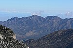
The Red Rock Canyon National Conservation Area in Clark County, Nevada, United States, is an area managed by the Bureau of Land Management as part of its National Landscape Conservation System, and protected as a National Conservation Area. It is about 15 miles (24 km) west of Las Vegas, and is easily seen from the Las Vegas Strip. More than three million people visit the area each year.The conservation area showcases a set of large red rock formations: a set of sandstone peaks and walls that were formed by thrust faults including the Keystone Thrust. The walls are up to 3,000 feet (910 m) high, making them a popular hiking and rock climbing destination. The highest point is La Madre Mountain, at 8,154 feet (2,485 m). A one-way, loop road, 13 miles (21 km) long, provides vehicle access to many of the features in the area. Several side roads and parking areas allow access to many of the area trails. A visitor center is at the start of the loop road. The loop road is also popular for bicycle touring; it begins with a moderate climb, then is mostly downhill or flat. The Rocky Gap Road in Red Rock Canyon NCA is a side canyon accessible only by an unmaintained primitive road from the scenic loop which mostly only off-road or high-clearance vehicles can access. State Route 159 cuts through the Cottonwood Valley, also a side trail of the Old Spanish Trail. The Wilson Cliffs, a massive escarpment, can be seen to the west from SR 159. Toward the southern end of the National Conservation Area are Spring Mountain Ranch State Park; the town of Blue Diamond; and Bonnie Springs Ranch, which includes a replica of a western ghost town, but which in 2019 was sold and closed to the public.

Excerpt from the Wikipedia article Red Rock Canyon National Conservation Area (License: CC BY-SA 3.0, Authors, Images).

Red Rock Canyon National Conservation Area
Red Rock Visitor Center Road, Las Vegas

Geographical coordinates (GPS) Address Phone number Website External links Nearby Places
placeShow on map

Wikipedia: Red Rock Canyon National Conservation AreaContinue reading on Wikipedia

Geographical coordinates (GPS)

Latitude Longitude
N 36.135574 ° E -115.42724 °
placeShow on map

Address

Red Rock Visitors Center

Red Rock Visitor Center Road 1000
89161 Las Vegas
Nevada, United States
mapOpen on Google Maps

Phone number

call+1(702)5155367

Website
redrockcanyonlv.org

linkVisit website

linkWikiData (Q1143382)
linkOpenStreetMap (302170473)

Red Rock Canyon National Conservation Area view 031513
Share experience

Nearby Places

Blue Diamond Hill housing proposals

Since 2002, there have been various housing proposals for Blue Diamond Hill, located in rural Clark County, Nevada. The proposed site is located west of Las Vegas, near the Red Rock Canyon National Conservation Area. The Blue Diamond Mine has operated on the land since the 1920s, but the property otherwise remains vacant. Each of the proposed housing projects have received some opposition from environmentalists, citing concerns about the impact that such a project would have on the surrounding area. In 2002, John Laing Homes proposed a community known as Cielo Encantado, with more than 8,400 homes on nearly 3,000 acres. Some residents of nearby Blue Diamond, Nevada were opposed to the project, which would bring 21,000 new residents to the area. By comparison, the town of Blue Diamond had 300 residents. Opponents also argued that a residential development would have a negative impact on the nearby Red Rock Canyon. After much opposition, John Laing withdrew its proposal in 2002. Within a few months, developer Jim Rhodes purchased 2,400 acres on Blue Diamond Hill and announced plans for Hidden Hills, a proposed community with up to 5,500 homes. This property is located near Red Rock Canyon, but not inside it. State senator Dina Titus introduced a bill to freeze the rural residential zoning that had already been in place at allowed one house for every two acres. Titus' bill was signed into law in May 2003, and the Clark County Commission passed a similar ordinance two days later. Rhodes filed a lawsuit in 2005, to overturn the law and ordinance. In 2009, a federal judge ruled in Rhodes' favor. The Clark County Commission subsequently approved a settlement deal with Rhodes that would allow development on the land, under certain conditions. In 2011, Rhodes proposed an unnamed community that would have 7,000 homes. The proposal received some opposition, and Rhodes later agreed to swap his land for other acreage, allowing for the preservation of Blue Diamond Hill. However, discussions with the Bureau of Land Management (BLM) ended in 2014, without a swap deal. The BLM did not swap for Rhodes' property because it felt it had been disrupted by the mining operation. In 2016, Rhodes proposed another unnamed community that would have 5,025 homes. This proposal also received some opposition, leading to several lawsuits. The number of homes was later reduced to 3,500. The project remains unbuilt, although Rhodes still intends to proceed with development. His company, Gypsum Resources, was approved in October 2022 to build 429 homes across 671 acres.