Coarsegold, California
Census-designated places in CaliforniaCensus-designated places in Madera County, CaliforniaUse mdy dates from July 2023

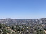
Coarsegold is a census-designated place in Madera County, California, United States. The population was 4,144 at the 2020 census, up from 1,840 in 2010. The Picayune Rancheria of Chukchansi Indians, a federally recognized tribe, is headquartered in Coarsegold.
Excerpt from the Wikipedia article Coarsegold, California (License: CC BY-SA 3.0, Authors, Images).Coarsegold, California
Southern Yosemite Highway,
Geographical coordinates (GPS) Address Website Nearby Places Show on map
 Continue reading on Wikipedia
 Geographical coordinates (GPS)
| Latitude | Longitude |
|---|---|
| N 37.262222222222 ° | E -119.70111111111 ° |
Address
Southern Yosemite Highway
California, United States
Open on Google Maps
Website
coarsegoldca.com