Mount Timpanogos

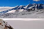
Mount Timpanogos, often referred to as Timp, is the second-highest mountain in Utah's Wasatch Range. Timpanogos rises to an elevation of 11,752 ft (3,582 m) above sea level in the Uinta-Wasatch-Cache National Forest. With 5,270 ft (1,610 m) of topographic prominence, Timpanogos is the 47th-most prominent mountain in the contiguous United States.The mountain towers about 7,000 ft (2,100 m) over Utah Valley, including the cities of Lehi, Provo, Orem, Pleasant Grove, American Fork, Lindon and others. The exposed massif of the mountain is made up entirely of limestone and dolomite from the Pennsylvanian period, and is about 300 million years old. Heavy winter snowfall is characteristic of this portion of the Wasatch Range, and avalanche activity is common in winter and spring. The mountain is also home to Timpanogos Cave National Monument, a series of decorated caves in the north end of the mountain that have guided ranger tours open daily to the public during the warmer months.
Excerpt from the Wikipedia article Mount Timpanogos (License: CC BY-SA 3.0, Authors, Images).Mount Timpanogos
Timpanogos Summit Trail,
Geographical coordinates (GPS) Address Nearby Places Show on map
 Continue reading on Wikipedia
 Geographical coordinates (GPS)
| Latitude | Longitude |
|---|---|
| N 40.390838842 ° | E -111.645947125 ° |
Address
Timpanogos Summit Trail
Timpanogos Summit Trail
84602
Utah, United States
Open on Google Maps